Typhoon Jongdari
Typhoon Jongdari was a strong, long-lived and erratic tropical cyclone that impacted Japan and East China in late July and early August 2018. Formed as the twelfth named storm of the 2018 typhoon season near Okinotorishima on July 24, Jongdari gradually intensified and developed into the fourth typhoon of the year on July 26. Influenced by an upper-level low and a subtropical ridge, Jongdari executed a rare counter-clockwise southeast of Japan on the next day. At that time, it also reached peak intensity. The typhoon made landfall in Kii Peninsula, over Mie Prefecture of Japan locally early on July 29.
| Typhoon (JMA scale) | |
|---|---|
| Category 2 typhoon (SSHWS) | |
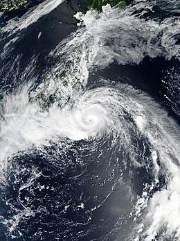
 Typhoon Jongdari shortly after peak intensity, while approaching Japan on July 28 | |
| Formed | July 23, 2018 |
| Dissipated | August 4, 2018 |
| Highest winds | 10-minute sustained: 140 km/h (85 mph) 1-minute sustained: 165 km/h (105 mph) |
| Lowest pressure | 960 hPa (mbar); 28.35 inHg |
| Fatalities | None |
| Damage | $1.46 billion (2018 USD) |
| Areas affected | Japan, East China |
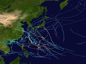
| Part of the 2018 Pacific typhoon season | |
Jongdari is one of the four Pacific tropical cyclones since 1951 that approached Honshu on a westward trajectory; the others were Typhoon Viola in 1966, Tropical Storm Ben in 1983, and Typhoon Lionrock in 2016.[1]
Meteorological history

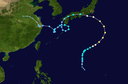
A tropical disturbance formed southeast of Guam on July 19 and tracked westward steadily.[2] After issuing a Tropical Cyclone Formation Alert on July 21, the Joint Typhoon Warning Center (JTWC) upgraded the system to a tropical depression early on July 22, although the location of its low-level circulation center was not clear.[3] The Japan Meteorological Agency (JMA), however, kept reporting it as a low-pressure area until it was upgraded to a tropical depression late on July 23.[4] After the slow consolidation for several days, the system was upgraded to a tropical storm near Okinotorishima at around 18:00 on July 24 by agencies such as JMA and JTWC, with an international name Jongdari.[5][6] A microwave imagery revealed a low-level forming eyewall next day, indicating a consolidating system. After JMA upgraded Jongdari to a severe tropical storm at noon,[7] the system accelerated northeastward under the influence of a near-equatorial ridge to the south.[8]
On July 26, as Jongdari started to interact with an upper-level cold-core low to the north which significantly enhanced poleward outflow,[9] it intensified to a typhoon in the afternoon despite increasingly unfavorable vertical wind shear.[10] Over the warm sea surface temperatures between 29 to 30 °C (84 to 86 °F) near the Ogasawara Islands, JMA reported that Jongdari had reached peak intensity at 00:00 UTC on July 27, with ten-minute maximum sustained winds of 140 km/h (85 mph), and a minimum central pressure of 965 hPa (28.50 inHg).[11] Although JTWC indicated Jongdari reached peak intensity at 12:00 UTC with one-minute maximum sustained winds of 175 km/h (110 mph), the rugged eye of Jongdari kept periodically visible with an elongated structure due to the further interaction of the upper-level low which had moved to the northwest side of the typhoon. As the steering influence transitioned to a subtropical ridge to the northeast, Jongdari executed a rare counter-clockwise turn to the southeast of Japan.[12]
Jongdari began to be inundated by subsidence on July 28, as the Fujiwhara effect had made the upper-level low move to the west of the typhoon.[13] It also initiated a weakening trend while accelerating northwestward and then westward toward the Japanese island of Honshu. At around 01:00 JST on July 29 (16:00 UTC July 28), Typhoon Jongdari made landfall over Ise, Mie Prefecture with ten-minute maximum sustained winds at 120 km/h (75 mph) and the central pressure at 975 hPa (28.79 inHg).[14][15] The storm weakened rapidly inland and made its second landfall over Buzen, Fukuoka Prefecture, at around 17:30 JST (08:30 UTC), with ten-minute sustained winds of 75 km/h (45 mph) and a central pressure of 992 hPa (29.29 inHg).[16] At around 10:30 CST (02:30 UTC) on August 3, Tropical Storm Jongdari made landfall over Jinshan District, Shanghai.[17] Jongdari rapidly weakened after landfall, dissipating on the next day.
Impact
Japan
24 people were injured when the typhoon hit Japan. JR-West train services were delayed or cancelled due to the storm. Although Jongdari didn't directly hit Hokuriku region, it did bring föhn wind to the area because it is located at the leeward slope of the Japanese Alps. Niigata prefecture recorded temperatures close to 40 °C (104 °F).[18] Agricultural damage in Chiba and Aichi Prefecture were about JP¥1.59 billion (US$14.3 million).[19][20] Preliminary industry loss were estimated between US$1.4–2 billion.[21]
See also
- 2018 Japan heat wave
- Typhoon Damrey (2012)
- Typhoon Lionrock (2016)
- Typhoon Noru (2017)
- Hurricane Sandy – An Atlantic hurricane in 2012 which executed a similar turn into the Northeastern U.S.
References
- Araki, Kentaro. "Typhoon No. 12's Unusual Path". Twitter. Retrieved July 29, 2018.
- "bwp152018.dat". Joint Typhoon Warning Center. Retrieved July 27, 2018.
- "Prognostic Reasoning for Tropical Depression 15W (Fifteen) Warning Nr 01". July 22, 2018. Archived from the original on July 24, 2018. Retrieved July 27, 2018.
- "WWJP25 RJTD 231800". Japan Meteorological Agency. July 23, 2018. Archived from the original on July 24, 2018. Retrieved July 27, 2018.
- "RSMC Tropical Cyclone Advisory 241800". Japan Meteorological Agency. July 24, 2017. Archived from the original on July 25, 2018. Retrieved July 27, 2017.
- "Prognostic Reasoning for Tropical Storm 15W (Jongdari) Warning Nr 12". July 24, 2018. Archived from the original on July 25, 2018. Retrieved July 27, 2018.
- "RSMC Tropical Cyclone Advisory 251200". Japan Meteorological Agency. July 25, 2017. Archived from the original on July 25, 2018. Retrieved July 28, 2017.
- "Prognostic Reasoning for Tropical Storm 15W (Jongdari) Warning Nr 15". July 25, 2018. Archived from the original on July 25, 2018. Retrieved July 28, 2018.
- "Prognostic Reasoning for Tropical Storm 15W (Jongdari) Warning Nr 19". July 26, 2018. Archived from the original on July 27, 2018. Retrieved July 28, 2018.
- "RSMC Tropical Cyclone Advisory 261200". Japan Meteorological Agency. July 26, 2017. Archived from the original on July 27, 2018. Retrieved July 28, 2017.
- "RSMC Tropical Cyclone Advisory 270000". Japan Meteorological Agency. July 27, 2017. Archived from the original on July 27, 2018. Retrieved July 28, 2017.
- "Prognostic Reasoning for Typhoon 15W (Jongdari) Warning Nr 23". July 27, 2018. Archived from the original on July 28, 2018. Retrieved July 28, 2018.
- "Prognostic Reasoning for Typhoon 15W (Jongdari) Warning Nr 25". July 28, 2018. Archived from the original on July 28, 2018. Retrieved July 28, 2018.
- "平成30年 台風第12号に関する情報 第73号" (in Japanese). Japan Meteorological Agency. July 28, 2018. Archived from the original on July 28, 2018. Retrieved July 28, 2018.
- "台風第12号 (ジョンダリ) 平成30年07月29日01時50分 発表" (in Japanese). Japan Meteorological Agency. July 28, 2018. Archived from the original on July 28, 2018. Retrieved July 28, 2018.
- "平成30年 台風第12号に関する情報 第94号" (in Japanese). Japan Meteorological Agency. July 29, 2018. Archived from the original on July 29, 2018. Retrieved July 29, 2018.
- "中央气象台03日10时30分发布台风登陆消息" (in Chinese). National Meteorological Center of CMA. August 3, 2018. Archived from the original on August 3, 2018. Retrieved August 3, 2018.
- "Typhoon Jongdari takes an unusual path across Japan". Aljazeera. July 30, 2018. Retrieved July 31, 2018.
- "台風12号:県農林水産被害 総額10億3543万円 /愛知" (in Japanese). Mainichi Shimbun. August 10, 2018. Retrieved October 10, 2018.
- "台風12号の影響による農林水産業への被害について(第3報兼最終報)" (in Japanese). Chiba Local Government. September 10, 2018. Retrieved October 10, 2018.
- News Typhoon Jongdari, July 2018 Typhoon Jongdari (pdf) (Report). Credit Suisse. August 2, 2018. Retrieved October 12, 2018.
- CMA (December 4, 2018). Member Report: China (PDF). ESCAP/WMO Typhoon Committee. ESCAP/WMO Typhoon Committee. pp. 1–2. Archived from the original (PDF) on December 4, 2018. Retrieved December 4, 2018.
External links
| Wikimedia Commons has media related to Typhoon Jongdari (2018). |
- JMA General Information of Typhoon Jongdari (1812) from Digital Typhoon
- 15W.JONGDARI from the U.S. Naval Research Laboratory
