Tutayev
Tutayev (Russian: Тута́ев) is a town in Yaroslavl Oblast, Russia. Population: 41,005 (2010 Census);[2] 42,644 (2002 Census);[7] 39,822 (1989 Census).[8] It has previously been called Romanov-Borisoglebsk, and before that it was two towns separated by the Volga River: Romanov and Borisoglebsk.
Tutayev Тутаев | |
|---|---|
Town[1] | |
 Flag  Coat of arms | |
Location of Tutayev 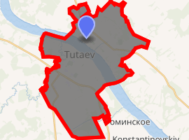
| |
 Tutayev Location of Tutayev  Tutayev Tutayev (Yaroslavl Oblast) | |
| Coordinates: 57°53′N 39°33′E | |
| Country | Russia |
| Federal subject | Yaroslavl Oblast[1] |
| Founded | 1822 |
| Elevation | 130 m (430 ft) |
| Population | |
| • Total | 41,005 |
| • Estimate (2018)[3] | 40,154 (-2.1%) |
| • Subordinated to | town of oblast significance of Tutayev[1] |
| • Capital of | Tutayevsky District[1], town of oblast significance of Tutayev[1] |
| • Municipal district | Tutayevsky Municipal District[4] |
| • Urban settlement | Tutayev Urban Settlement[4] |
| • Capital of | Tutayevsky Municipal District, Tutayev Urban Settlement[4] |
| Time zone | UTC+3 (MSK |
| Postal code(s)[6] | 152300–152303 |
| OKTMO ID | 78643101001 |
History
Before 1918, it was called Romanov-Borisoglebsk (Рома́нов-Борисогле́бск), and before 1822, when an order of the Tsar united them, there were two separate towns: Romanov (on the left bank of the Volga) and Borisoglebsk (on the right bank). Romanov has existed since the 14th century and Borisoglebsk—since the 15th century. In the 15th century, Romanov was ruled by the khans of Nogay Horde.
Overview
The majority of the population lives on the right bank of the river (the former Borisoglebsk). The areas of town nearest to the Volga's right bank have many old wooden houses and historical buildings (including the Resurrection Cathedral), but further away from the river, Soviet-era apartment buildings predominate. There is no bridge across the Volga in Tutayev, so people have to use a ferry or, alternatively, travel north to Rybinsk or south to Yaroslavl to cross.
Administrative and municipal status
Within the framework of administrative divisions, Tutayev serves as the administrative center of Tutayevsky District, even though it is not a part of it.[1] As an administrative division, it is incorporated separately as the town of oblast significance of Tutayev—an administrative unit with the status equal to that of the districts.[1] As a municipal division, the town of oblast significance of Tutayev is incorporated within Tutayevsky Municipal District as Tutayev Urban Settlement.[4]
Economy
Tutayev is home to the Tutayev Motor Plant, which is one of the largest producers of diesel engines for automobiles and tractors in the Commonwealth of Independent States.
Religion
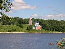
The following churches are located on the left bank of the river: the Krestovozdvizhensky Cathedral (1658), the Kazan-Preobrazhensky Church (1758), the Savior-Archangel Church (1746–1751), the Pokrovskaya Church (1674), the Church of the Trinity on the Country Churchyard (1783), the Church of St. Tikhon (1911), the Blagoveschensk Church (1660), and the Leontyevskaya-Voznesenskaya Church (1795).
See also
- Romanov (sheep), a breed of sheep that takes its name from the town of Romanov
References
Notes
- Law #12-z
- Russian Federal State Statistics Service (2011). "Всероссийская перепись населения 2010 года. Том 1" [2010 All-Russian Population Census, vol. 1]. Всероссийская перепись населения 2010 года [2010 All-Russia Population Census] (in Russian). Federal State Statistics Service.
- "26. Численность постоянного населения Российской Федерации по муниципальным образованиям на 1 января 2018 года". Federal State Statistics Service. Retrieved January 23, 2019.
- Law #65-z
- "Об исчислении времени". Официальный интернет-портал правовой информации (in Russian). June 3, 2011. Retrieved January 19, 2019.
- Почта России. Информационно-вычислительный центр ОАСУ РПО. (Russian Post). Поиск объектов почтовой связи (Postal Objects Search) (in Russian)
- Russian Federal State Statistics Service (May 21, 2004). "Численность населения России, субъектов Российской Федерации в составе федеральных округов, районов, городских поселений, сельских населённых пунктов – районных центров и сельских населённых пунктов с населением 3 тысячи и более человек" [Population of Russia, Its Federal Districts, Federal Subjects, Districts, Urban Localities, Rural Localities—Administrative Centers, and Rural Localities with Population of Over 3,000] (XLS). Всероссийская перепись населения 2002 года [All-Russia Population Census of 2002] (in Russian).
- "Всесоюзная перепись населения 1989 г. Численность наличного населения союзных и автономных республик, автономных областей и округов, краёв, областей, районов, городских поселений и сёл-райцентров" [All Union Population Census of 1989: Present Population of Union and Autonomous Republics, Autonomous Oblasts and Okrugs, Krais, Oblasts, Districts, Urban Settlements, and Villages Serving as District Administrative Centers]. Всесоюзная перепись населения 1989 года [All-Union Population Census of 1989] (in Russian). Институт демографии Национального исследовательского университета: Высшая школа экономики [Institute of Demography at the National Research University: Higher School of Economics]. 1989 – via Demoscope Weekly.
Sources
- Государственная Дума Ярославской области. Закон №12-з от 7 февраля 2002 г «Об административно-территориальном устройстве Ярославской области и порядке его изменения», в ред. Закона №67-з от 21 декабря 2012 г. «О внесении изменений в отдельные законодательные акты Ярославской области и признании утратившими силу отдельных законодательных актов (положений законодательных актов) Ярославской области». Вступил в силу через шесть месяцев со дня официального опубликования. Опубликован: "Губернские вести", №11, 15 февраля 2002 г. (State Duma of Yaroslavl Oblast. Law #12-z of February 7, 2002 On the Administrative-Territorial Structure of Yaroslavl Oblast and on the Procedures of Its Change, as amended by the Law #67-z of December 21, 2012 On Amending Various Legislative Acts of Yaroslavl Oblast and on Abrogation of Various Legislative Acts (Clauses of Legislative Acts) of Yaroslavl Oblast. Effective as of the day six months from the day of the official publication.).
- Государственная Дума Ярославской области. Закон №65-з от 21 декабря 2004 г. «О наименованиях, границах и статусе муниципальных образований Ярославской области», в ред. Закона №59-з от 28 декабря 2011 г «Об изменении статуса рабочего посёлка Песочное Рыбинского района и о внесении изменений в отдельные законодательные акты Ярославской области». Вступил в силу через 10 дней со дня официального опубликования. Опубликован: "Губернские вести", №70, 23 декабря 2004 г. (State Duma of Yaroslavl Oblast. Law #65-z of December 21, 2004 On the Names, Borders, and Status of the Municipal Formations of Yaroslavl Oblast, as amended by the Law #59-z of December 28, 2011 On Changing the Status of the Work Settlement of Pesochnoye of Rybinsky District and on Amending Various Legislative Acts of Yaroslavl Oblast. Effective as of after 10 days from the day of the official publication.).