Tuckasegee River
The Tuckasegee River (variant spellings include Tuckaseegee and Tuckaseigee)[1] flows entirely within western North Carolina. It begins its course in Jackson County above Cullowhee at the confluence of Panthertown and Greenland creeks. It flows in a northwesterly direction into Swain County, where it joins the Oconaluftee before heading northwest. Bryson City developed along both sides of the river around this area, and Bryson City Island Park was developed. The river next enters Fontana Lake and ultimately flows as a tributary into the Little Tennessee River.
| Tuckasegee River | |
|---|---|
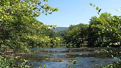 View upriver from Old River Rd. above Bryson City | |
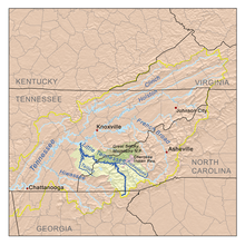 The Little Tennessee drainage basin | |
| Location | |
| Country | United States |
| State | North Carolina |
| Physical characteristics | |
| Source | confluence of Panthertown and Greenland creeks |
| • coordinates | 35°10′6″N 83°0′41″W |
| • elevation | 3,969 ft (1,210 m) |
| Mouth | |
• location | Lake Fontana |
• coordinates | 35°26′5″N 83°35′4″W |
• elevation | 1,703 ft (519 m) |
| Length | 60 mi (97 km) |
| Basin size | 655 sq mi (1,700 km2) |
| Discharge | |
| • location | Bryson City |
| • average | 1,584 cu ft/s (44.9 m3/s) |
| • minimum | 31 cu ft/s (0.88 m3/s) |
| • maximum | 61,600 cu ft/s (1,740 m3/s) |
| Basin features | |
| River system | Little Tennessee → Tennessee → Ohio → Mississippi |
| Tributaries | |
| • left | West Fork Tuckasegee River, Savannah Creek, Barkers Creek, Connelley Creek, Kirkland Creek |
| • right | Tanasee Creek, Caney Fork, Wayehutta Creek, Mill Creek, Scott Creek, Dicks Creek, Camp Creek, Oconaluftee River, Cooper Creek, Deep Creek, Lands Creek, Dicks Creek, Noland Creek, Forney Creek |
The name Tuckasegee may be an anglicisation of the Cherokee language word daksiyi—[takhšiyi] in the local Cherokee variety, meaning 'Turtle Place.' The river is dotted with stone fishing weirs built by Native Americans; this practice may have preceded the Cherokee in the area. The weirs are most easily viewed when water levels are low.[2]
Fishing, hiking, and paddling are among the recreational opportunities along the river.
References
- "Tuckasegee River". Geographic Names Information System. United States Geological Survey. Retrieved 2010-07-01.
- See Anne Frazier Rogers, "Fish weirs as part of the cultural landscape," Appalachian Cultural Resources Workshop Papers, National Park Service. Photo, Allman fish weir
| Authority control |
|
|---|