Trnava District
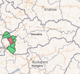
Trnava District (Slovak: okres Trnava) is a district in the Trnava Region of western Slovakia.[1] In its present borders the district was established in 1996. Before that date Hlohovec district was a part of it. It comprises the villages around the Trnava, which forms an administrative, cultural and economy center of the district. The towns and villages are partly bedroom communities for the people who work in Bratislava, or Trnava.
Trnava District | |
|---|---|
| |
| Country | Slovakia |
| Region (kraj) | Trnava Region |
| Area | |
| • Total | 741 km2 (286 sq mi) |
| Population (2001) | |
| • Total | 126,864 |
| • Density | 170/km2 (440/sq mi) |
| Time zone | UTC+01:00 (CET) |
| • Summer (DST) | UTC+02:00 (CEST) |
| Telephone prefix | 33 |
Municipalities
- Biely Kostol
- Bíňovce
- Bohdanovce nad Trnavou
- Boleráz
- Borová
- Brestovany
- Bučany
- Buková
- Cífer
- Dechtice
- Dlhá
- Dobrá Voda
- Dolná Krupá
- Dolné Dubové
- Dolné Lovčice
- Dolné Orešany
- Horná Krupá
- Horné Dubové
- Horné Orešany
- Hrnčiarovce nad Parnou
- Jaslovské Bohunice
- Kátlovce
- Košolná
- Križovany nad Dudváhom
- Lošonec
- Majcichov
- Malženice
- Naháč
- Opoj
- Pavlice
- Radošovce
- Ružindol
- Slovenská Nová Ves
- Smolenice
- Suchá nad Parnou
- Šelpice
- Špačince
- Šúrovce
- Trnava
- Trstín
- Vlčkovce
- Voderady
- Zavar
- Zeleneč
- Zvončín
gollark: It's great! It has great performance and many underappreciated features like full text search.
gollark: Abstract syntax trees and basically anything else where you have various different types of thing with different properties.
gollark: And ADTs are a much nicer way to express some kinds of data than the kludges used in OOP.
gollark: `map (+1) xs` is way nicer than an equivalent for loop.
gollark: Pattern matching, ADTs, tail recursion support, higher order functions.
References
This article is issued from Wikipedia. The text is licensed under Creative Commons - Attribution - Sharealike. Additional terms may apply for the media files.