Trenčianske Bohuslavice
Trenčianske Bohuslavice (Slovak pronunciation: [ˈtɾɛntʃɪ̯anskɛ ˈbɔɦuslaʋitsɛ]; Hungarian: Bogoszló) is a village and municipality in Nové Mesto nad Váhom District in the Trenčín Region of western Slovakia.
Trenčianske Bohuslavice | |
|---|---|
Municipality | |
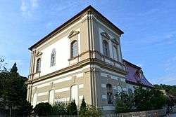 Chapel of the Immaculate Conception | |
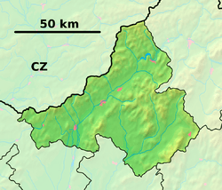 Trenčianske Bohuslavice Location of Trenčianske Bohuslavice in the Trenčín Region  Trenčianske Bohuslavice Trenčianske Bohuslavice (Slovakia) | |
| Coordinates: 48°48′N 17°52′E | |
| Country | Slovakia |
| Region | Trenčín |
| District | Nové Mesto nad Váhom |
| First mentioned | 1208 |
| Area | |
| • Total | 6.405 km2 (2.473 sq mi) |
| Elevation | 198 m (650 ft) |
| Population | |
| • Total | 947 |
| • Density | 150/km2 (380/sq mi) |
| Postal code | 913 07 (pošta Bošáca) |
| Area code(s) | 421-32 |
| Car plate | NM |
| Website | www.trencianskebohuslavice.sk |
History
In historical records the village was first mentioned in 1208.
Geography
The municipality lies at an altitude of 198 metres and covers an area of 6.405 km². It has a population of about 947 people.
gollark: You probably can't verify "actual-person-ness" without some sort of centralized authority... unless you have some kind of convoluted web of trust mechanism but I'm sure that could be abused horribly.
gollark: Centralized bad.
gollark: Yes, exactly.
gollark: What people would *like*, I suppose, is "each actual person gets some fixed amount of coins per day", but there's no way to enforce that cryptographically.
gollark: Yes, I agree, although the alternative seems to be pretty much be "burn electricity and computing power for new stuff".
External links
![]()
This article is issued from Wikipedia. The text is licensed under Creative Commons - Attribution - Sharealike. Additional terms may apply for the media files.