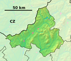
Trebichava
Trebichava (Hungarian: Terbók) is a village and municipality in Bánovce nad Bebravou District in the Trenčín Region of north-western Slovakia.
Trebichava | |
|---|---|
Municipality | |
 Trebichava Location of Trebichava in the Trenčín Region  Trebichava Trebichava (Slovakia) | |
| Coordinates: 48°49′N 18°18′E | |
| Country | Slovakia |
| Region | Trenčín |
| District | Bánovce nad Bebravou |
| First mentioned | 1396 |
| Area | |
| • Total | 11.765 km2 (4.542 sq mi) |
| Elevation | 340 m (1,120 ft) |
| Population | |
| • Total | 35 |
| • Density | 3.0/km2 (7.7/sq mi) |
| Postal code | 956 53 (pošta Slatina nad Bebravou) |
| Area code(s) | 421-38 |
| Car plate | BN |
| Website | trebichava.sk |
History
In historical records the village was first mentioned in 1396.
Geography
The municipality lies at an altitude of 340 metres and covers an area of 11.765 km². It has a population of about 35 people.
gollark: Obviously.
gollark: Stone dragons would just sit there.
gollark: Pillow dragons would manage to win by being cute and/or absorbing impacts easily.
gollark: Also, nexuses/nexi are powerful, according to the description.
gollark: Nebulae would win fights by saying "Hey, stop fighting me! Look at this cool constellation here? See that star there? It's 500 light-years from this planet, and the latest data shows that it might have habitable planets! Cool, right?" and distracting their opponents.
This article is issued from Wikipedia. The text is licensed under Creative Commons - Attribution - Sharealike. Additional terms may apply for the media files.