Omastiná
Omastiná (Hungarian: Csermely) is a village and municipality in Bánovce nad Bebravou District in the Trenčín Region of north-western Slovakia.
Omastiná | |
|---|---|
Municipality | |
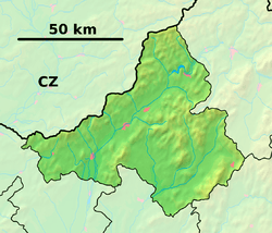
 Omastiná Location of Omastiná in the Trenčín Region  Omastiná Omastiná (Slovakia) | |
| Coordinates: 48°47′N 18°23′E | |
| Country | Slovakia |
| Region | Trenčín |
| District | Bánovce nad Bebravou |
| First mentioned | 1389 |
| Area | |
| • Total | 12.448 km2 (4.806 sq mi) |
| Elevation | 300 m (1,000 ft) |
| Population | |
| • Total | 43 |
| • Density | 3.5/km2 (8.9/sq mi) |
| Postal code | 956 41 (pošta Uhrovec) |
| Area code(s) | 421-38 |
| Car plate | BN |
History
In historical records the village was first mentioned in 1389.
Geography
The municipality lies at an altitude of 300 metres and covers an area of 12.448 km². It has a population of about 43 people.
gollark: Excellent. PotatOS's scheduler can now measure execution time in nanoseconds for no particular reason.
gollark: Anyone know how `ccemux.nanoTime` works?
gollark: I try and make my stuff reasonably OS/platform-independent.
gollark: blittle?
gollark: PotatOS has a semi-independent VFS/sandbox library, but I had to add a *lot* of patches for sandbox escapes and stuff to PotatoBIOS, so it's hard to use it separately.
This article is issued from Wikipedia. The text is licensed under Creative Commons - Attribution - Sharealike. Additional terms may apply for the media files.