Malá Hradná
Malá Hradná (Hungarian: Kisradna) is a village and municipality in Bánovce nad Bebravou District in the Trenčín Region of north-western Slovakia.
Malá Hradná | |
|---|---|
Municipality | |
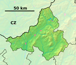 Malá Hradná Location of Malá Hradná in the Trenčín Region  Malá Hradná Malá Hradná (Slovakia) | |
| Coordinates: 48°46′N 18°10′E | |
| Country | Slovakia |
| Region | Trenčín |
| District | Bánovce nad Bebravou |
| First mentioned | 1329 |
| Area | |
| • Total | 7.910 km2 (3.054 sq mi) |
| Elevation | 290 m (950 ft) |
| Population | |
| • Total | 387 |
| • Density | 49/km2 (130/sq mi) |
| Postal code | 956 54 (pošta Veľké Držkovce) |
| Area code(s) | 421-38 |
| Car plate | BN |
History
In historical records the village was first mentioned in 1329.
Geography
The municipality lies at an altitude of 290 metres and covers an area of 7.910 km2. It has a population of about 387 people.
gollark: It would probably be helpful if you explain why you need this to avoid XY problems.
gollark: The general standard for encrypted partition things, on Linux anyway, is LUKS. You *may* just be able to put a valid LUKS header in front of a block of random data, but it would be basically equivalent to just *actually* make an encrypted partition with a random key you then delete.
gollark: I don't know, but I doubt "fibre channel" is the same as SAS.
gollark: I'm sure there's some sort of horrible USB adapter or adapter chain.
gollark: Also because I have no idea how to use unix text manipulation tools.
External links
- https://web.archive.org/web/20071217080336/http://www.statistics.sk/mosmis/eng/run.html
- http://www.farnostmalahradna.tym.sk
This article is issued from Wikipedia. The text is licensed under Creative Commons - Attribution - Sharealike. Additional terms may apply for the media files.