Trautmannsdorf an der Leitha
Trautmannsdorf an der Leitha is a town in the district of Bruck an der Leitha in Lower Austria in Austria.

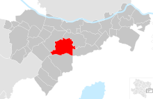
Trautmannsdorf an der Leitha in the district of Bruck an der Leitha
Trautmannsdorf an der Leitha | |
|---|---|
 Coat of arms | |
 Trautmannsdorf an der Leitha Location within Austria | |
| Coordinates: 48°1′N 16°37′E | |
| Country | Austria |
| State | Lower Austria |
| District | Bruck an der Leitha |
| Government | |
| • Mayor | Heinz-Christian Berthold |
| Area | |
| • Total | 35.44 km2 (13.68 sq mi) |
| Elevation | 168 m (551 ft) |
| Population (2018-01-01)[2] | |
| • Total | 2,886 |
| • Density | 81/km2 (210/sq mi) |
| Time zone | UTC+1 (CET) |
| • Summer (DST) | UTC+2 (CEST) |
| Postal code | 2454 |
| Area code | 02169 |
| Website | www.trautmannsdorf.at |
Geography
Trautmannsdorf an der Leitha lies in the industrial area of Lower Austrica. The Leitha River crosses the municipality. It is the third-largest municipality of the district. About 9.56 percent of the municipality is forested.
The municipality contains the following villages:
- Gallbrunn (population 736 as of 1 January 2017)
- Sarasdorf (population 568 as of 1 January 2017)
- Stixneusiedl (population 580 as of 1 January 2017)
- Trautmannsdorf an der Leitha (population 979 as of 1 January 2017)
gollark: Labels work out as about 30 bytes per tick with efficient base 187 encoding.
gollark: Or bundled redstone. Adjacent computers can do 2 bytes per tick over bundled.
gollark: <@509348730156220427> I have some useless ideas I can't be bothered to make:- mesh networking- communication between adjacent computers by changing and reading labels very fast
gollark: <@237328509234708481> If you make /bin a path for programs please also make require try loading from /lib by default.
gollark: Yes you can.
References
- "Dauersiedlungsraum der Gemeinden Politischen Bezirke und Bundesländer - Gebietsstand 1.1.2018". Statistics Austria. Retrieved 10 March 2019.
- "Einwohnerzahl 1.1.2018 nach Gemeinden mit Status, Gebietsstand 1.1.2018". Statistics Austria. Retrieved 9 March 2019.
This article is issued from Wikipedia. The text is licensed under Creative Commons - Attribution - Sharealike. Additional terms may apply for the media files.