Topčiderka
Topčiderska River (Serbian: Топчидерска река / Topčiderska reka, "Topčider River"), or colloquially Topčiderka (Serbian Cyrillic: Топчидерка), or Topčiderski Creek (Serbian: Топчидерски поток / Topčiderski potok, "Topčider Creek"), is a river in north-central Serbia, a 30 km-long right tributary to the Sava river to which it flows in the urban section of Belgrade. It is one of the 40 rivers, streams and creeks that flow or used to flow through Belgrade (majority of them is conducted underground into the city sewage system).
| Topčiderska River Топчидерка / Topčiderka | |
|---|---|
 | |
| Native name | Topčiderska reka (Serbian) |
| Location | |
| Country | Serbia |
| Physical characteristics | |
| Source | |
| • location | Lipovica Forest, Kosmaj mountain |
| Mouth | |
• location | Sava, at Belgrade |
• coordinates | 44°47′32″N 20°25′31″E |
• elevation | 192 m (630 ft) |
| Basin size | 147 km2 (57 sq mi) |
| Basin features | |
| Progression | Sava→ Danube→ Black Sea |
Course
The Topčiderska reka originates in the Lipovica (Lipovica Forest) area, on the northern slopes of the Parcanski vis, the northern section of the Kosmaj mountain, at an altitude of 192 meters. Originally, it flows to the north-east, until it reaches the Belgrade's suburb of Ripanj, in the municipality of Voždovac. From there, the river flows generally into the north-west direction, along the Šumadija's geological bar into which the river carved its epigenetic valley and formed a watershed. The valley of Topčiderka is a natural route for the Belgrade-Niš railway.
After it flows between the villages of Pinosava and Rušanj (western slopes of the Avala mountain), the Topčiderka enters the urban section of Belgrade (Rakovica municipality) at the neighborhood of Resnik. It continues through the neighborhoods of Kijevo, Labudovo Brdo, Kneževac, Rakovica, Miljakovac and Kanarevo Brdo.
At this point, the river enters the territory of the municipality of Savski Venac where the vast woods of Topčider are formed. After the Topčiderka passes next to the Konak of Prince Miloš and the Belgrade hippodrome, it empties into the Čukarica Bay of the Sava river, across the northern tip of the Ada Ciganlija island, at an altitude of 69 meters. It drains an area of 147 km² (out of which 70% is agricultural land) with 35 tributaries and belongs to the Black Sea drainage basin.
Two sections along the river are organized as the game hunting grounds. One is Lipovička Šuma, near the spring of the river and another, Topčiderska Reka, at the Rakovica-Čukarica municipal border.[1]
Tributaries
Tributaries of the Topčiderka include:
Pollution
Despite its river bed has been arranged and concreted in majority of its urban course, the Topčiderka still floods the surrounding areas of Belgrade during heavy rains. Over 160,000 inhabitants lives in the urban section of Topčiderka. As a result of high density of population and sewage systems, industrial zones the river passes through and advanced erosion, Topčiderka is notoriously highly polluted, which resulted in City government's 2007 Study on cleaning the river and its drainage basin, which was officially presented in May 2008. The study is the first ever complete collection of measures for Topčiderka improvement. Concrete bed for the further 7 kilometers are projected, so as the seven small reservoirs (added to the already existing two) which will prevent floodings and make irrigation possible. City architect, Đorđe Bobić, stated that "once we protected the city from the river, now the time has come to protect the river from the city".[2]
When Ada Ciganlija was connected to the mainland via the embankments in 1967, arm of the Sava river which separated the island was transformed into the Čukarica Bay in its northern part. Since the early 1980s there is a constant ecological problem due to the massive pollution of the bay as a result of the polluted waters of the Topčiderka river which flows into the bay. The garbage and highly polluted silt fills the bay and creates shoals. During low-tide, the bay is unusable for the boats in the marina, located in the middle of the bay or for the kayakers of Partizan and Crvena Zvezda who use the bay for practice. The silt is up to 5 m (16 ft) thick, smells bad and is poisonous so the swimming in the bay is forbidden. In 2011 the estimated amount of garbage sludge in the bay was 120,000 m3 (4,200,000 cu ft). The sludge cannot simply be dredged and thrown in the Sava further downstream due to the toxicity. The plan to build a treatment plant on the bank near the Belgrade Fair which would detoxicate the sludge and produce fertilizer from it was scrapped due to the high costs. For now, the silt is being dredged and vegetation cut just enough to make it navigable for the small boats in the marina.[3]
As a result of collection waste from farming households in its upper course, illegal housing and untreated industrial wastewater from the Rakovica industrial region, the mouth of the Topčiderka into the Sava was described by the environmentalists in March 2019 as the "open concrete (waste) collector".[4]
Transportation
After the Ada Bridge across the Sava was finished in 2012, a major Radnička interchange was built above the river's mouth into the Čukarica Bay. Within the projects of the optimizing the bridge's function since then, there are some changes concerning the river itself. Within the scope of the construction of the new tram routes across the bridge, the already existing tram bridge across the Topčiderka will be removed but the pillars will be preserved and used for the new track bridge. The planned construction of the road connection of the bridge with Rakovica includes the relocation of the Topčiderka riverbed for 1 km (0.62 mi), construction of a new bridge across the Pere Velimirovića Steeet in Rakovica's neighborhood of Kanarevo Brdo and reconstruction and widening of the Bulevar patrijarha Pavla which is designated to be the most important traffic route in this part of Belgrade. Stretching along the valley of the river, it is envisioned as the main transit corridor which would connect the European route E75 (Belgrade-Niš highway), New Belgrade, Ada Bridge, Patrijarha Dimitrija Street, Ibar Highway, Kružni put and the Belgrade bypass. As of January 2018, the timeline of the entire project is unknown, as only a partial request for tendering was announced.[5]
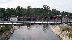
Due to the road, bridge and interchange construction, the section of the river was moved 20 m (66 ft) to the east. As this is the location where the stream of Kaljavi Potok flows into the Topčiderka, its mouth was also moved while the final 100 m (330 ft) of its flow were conducted underground, through the pipes. The new bridge is 19 m (62 ft) long and 26 m (85 ft) wide, with three lanes in each direction.[6] The works on the relocation of the river began on 1 March 2018,[7] and were finished by August 2019.[8] The bridge became operational on 22 March 2019.[9]
Future projects
In September 2017, the project for the reconstruction of Careva Ćuprija was announced. A work of Marija Krsmanović Stringeta, Anđelka Badnjar and Milena Kordić, the projected new complex will include the hotel and the sports center on the bank of the river, instead of the present "Jugopetrol" oil depots. The project will include the new pathways along the river, which would directly connect the Belgrade Hippodrome with the main road along the Sava river.[10]
References
- Branka Vasiljević (5 August 2018). "Lovci u Beograd stižu porodično" [Hunters travel to Belgrade with their families]. Politika (in Serbian).
- "Predstoji uređenje toka "Topčiderke"", Politika (in Serbian), p. 24, 30 October 2007
- Dimitrije Bukvić (June 2011), "Sprudovi otpada koče čamdžije" [Garbage shoals hinder the boatmen], Politika (in Serbian)
- Branka Vasliljević (23 March 2019). "Sava i Dunav odolevaju zagađenju, rečice i potoci postali kolektori" [Sava and Danube resist the pollution, streams and brooks turned into collectors]. Politika (in Serbian). p. 12.
- Dejan Aleksić (20 January 2018). "Za pun život Mosta na Adi još tri velika koraka" [Three more big steps for the full life of the Ada Bridge]. Politika (in Serbian). p. 15.
- Dejan Aleksić (20 February 2018). "Za izmeštanje korita Topčiderske reke zainteresovane tri firme" [Three companies interested into the relocation of the Topčiderska reka]. Politika (in Serbian). p. 15.
- Dejan Aleksić (2 March 2018). "Почело измештање корита Топчидерске реке" [Relocation of the Topčiderska reka riverbed began]. Politika (in Serbian). p. 14.
- Dejan Aleksić (13 August 2019). Мајстори од септембра на потезу од Кошутњака до Пере Велимировића [Workers on the Košutnjak-Pera Velimirović section from September]. Politika (in Serbian). p. 14.
- Dejan Aleksić (23 March 2019). "Преко Топчидерке новим мостом" [Over Topčiderka via a new bridge]. Politika (in Serbian). p. 12.
- Daliborka Mučibabić (29 September 2017), "Hipodrom će povezati Adu i Košutnjak" [Hippodrome will connect Ada and Košutnjak], Politika (in Serbian), p. 17
Sources
- Mala Prosvetina Enciklopedija, Third edition (1985); Prosveta; ISBN 86-07-00001-2
- Jovan Đ. Marković (1990): Enciklopedijski geografski leksikon Jugoslavije; Svjetlost-Sarajevo; ISBN 86-01-02651-6