Thotlavalluru mandal
Thotlavalluru mandal is one of the 50 mandals in Krishna district of the Indian state of Andhra Pradesh. It is under the administration of Vijayawada revenue division and its headquarters are located at North Valluru.[2][3] The mandal lies on the banks of Krishna River and is bounded by Kankipadu, Vuyyuru and Pamidimukkala mandals.[4] The mandal is also a part of the Andhra Pradesh Capital Region under the jurisdiction of APCRDA.[5]
Thotlavalluru mandal | |
|---|---|
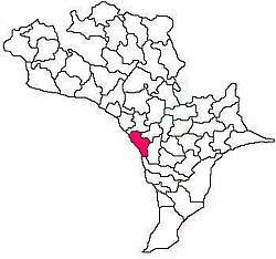
 Mandal map of Krishna district showing Thotlavalluru mandal (in Rose Colour) | |
.svg.png) Thotlavalluru mandal Location in Andhra Pradesh, India | |
| Coordinates: 16°21′18″N 80°46′27″E | |
| Country | India |
| State | Andhra Pradesh |
| District | Krishna |
| Headquarters | North Valluru |
| Population (2011)[1] | |
| • Total | 38,641 |
| Languages | |
| • Official | Telugu |
| Time zone | UTC+5:30 (IST) |
| Vehicle registration | AP 16 |
| Website | http://www.thotlavalluru.com/ |
Towns and villages
As of 2011 census, the mandal has 16 villages.[6][2]
The settlements in the mandal are listed below:
- Boddapadu
- Bhadrirajupalem
- Chagantipadu
- Chinapulipaka
- Devarapalle
- Garikaparru
- Gurivindapalle
- Iluru
- Kanakavalli
- Kummamuru
- Madhurapuram
- Mulakalapalle
- North Valluru
- Penamakuru
- Royyuru
- South Valluru
- Yakamuru
- Pamulapati Vari Palem
gollark: ···
gollark: YET.
gollark: And I don't eat cereal in a vacuum.
gollark: I was going to say that air was a fluid.
gollark: ... sigh.
See also
References
- "Census 2011". The Registrar General & Census Commissioner, India. Retrieved 25 August 2014.
- "Krishna District Mandals" (PDF). Census of India. pp. 508, 529. Retrieved 21 January 2015.
- "Administrative Setup". Krishna District Official Website. Retrieved 15 October 2014.
- "Mandals in Krishna district". aponline.gov.in. Archived from the original on 13 December 2014. Retrieved 14 October 2014.
- "Andhra Pradesh Capital Region Development Authority Act, 2014" (PDF). News19. Municipal Administration and Urban Development Department. 30 December 2014. Archived from the original (PDF) on 18 February 2015. Retrieved 9 February 2015.
- "Vemuru mandal villages" (PDF). Commissioner of Land Administration, Govt. of Andhra Pradesh. National Informatics Centre. p. 14. Archived from the original (PDF) on 10 October 2014. Retrieved 11 February 2015.
This article is issued from Wikipedia. The text is licensed under Creative Commons - Attribution - Sharealike. Additional terms may apply for the media files.