Jaggayyapeta mandal
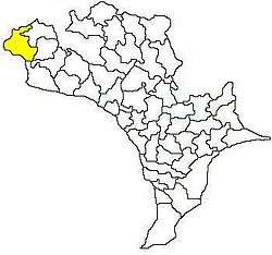
Jaggayyapeta mandal is one of the 50 mandals in Krishna district of the state of Andhra Pradesh in India. It is under the administration of Vijayawada revenue division and the headquarters are located at Jaggayyapeta town.[2][3] Krishna River flows through the mandal and is bounded by Penuganchiprolu, Nandigama, Chandarlapadu mandals of Krishna district, some part of Guntur district, Nalgonda and Khammam districts of Telangana.[4]
Jaggayyapeta mandal | |
|---|---|
 Mandal map of Krishna district showing Vijayawada (rural) mandal (in yellow) | |
.svg.png) Jaggayyapeta mandal Location in Andhra Pradesh, India | |
| Coordinates: 16.8920°N 80.0976°E | |
| Country | India |
| State | Andhra Pradesh |
| District | Krishna |
| Headquarters | Jaggayyapeta |
| Population (2011)[1] | |
| • Total | 103,559 |
| Languages | |
| • Official | Telugu |
| Time zone | UTC+5:30 (IST) |
Towns and villages
As of 2011 census, the mandal has 18 settlements. It includes 1 town and 24 villages.[2]
The settlements in the mandal are listed below:
- Annavaram
- Anumanchipalle
- Balusupadu
- Bandipalem
- Buchavaram
- Budawada
- Chillakallu
- Garikapadu
- Gandrai
- Gowravaram
- Jaggayyapeta (CT)
- Jayanthipuram
- Kowthavari Agraharam
- Malkapuram
- Muktheswarapuram
- Pochampalle
- Ramachandrunipeta
- Ravikampadu
- Ravirala
- Shermohammedpet
- Takkellapadu
- Tirumalagiri
- Torraguntapalem
- Tripuravaram
- Vedadri
Note: (CT)-Census town[5]
gollark: I consider it vaguely suitable for highly low level things, but not otherwise.
gollark: It's as "good" as Go's.
gollark: When `malloc` fails, my software overwrites its entire memory space with pure bees.
gollark: Prove that it can't, simple.
gollark: Just formally prove your code cannot fail.
References
- "Census 2011". The Registrar General & Census Commissioner, India. Archived from the original on 24 September 2015. Retrieved 12 September 2014.
- "Krishna District Mandals" (PDF). Census of India. pp. 474, 523. Retrieved 21 January 2015.
- "Administrative Setup". Krishna District Official Website. National Informatics Centre. Archived from the original on 20 October 2014. Retrieved 9 February 2015.
- "Mandals in Krishna district". aponline.gov.in. Archived from the original on 13 December 2014. Retrieved 15 September 2014.
- "Some Concepts and Definitions" (PDF). Census of India 2011. Retrieved 19 January 2015.
This article is issued from Wikipedia. The text is licensed under Creative Commons - Attribution - Sharealike. Additional terms may apply for the media files.