Thingoe Hundred
Thingoe was a hundred of Suffolk, consisting of 31,850 acres (128.9 km2).[1]
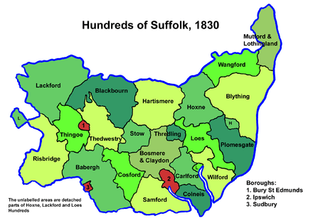
One of the smaller hundreds of Suffolk, around 9 miles (14 km) wide and 11 miles (18 km) long, Thingoe contained the borough of Bury St Edmunds on its eastern border, though the town was considered a separate jurisdiction. The remainder of the hundred consisted of the land to the west of Bury St Edmunds. The River Lark rises in the hundred, flowing north to the River Little Ouse.
The name derives from the words thing, a Norse word meaning "assembly", and howe, again Norse, meaning detached hill or mound.[2]
Parishes
Suffolk hundreds
Thingoe Hundred consisted of the following 18 parishes:[1][3]
| Parish | Area (acres) |
|---|---|
| Barrow | 2810 |
| Brockley | 1080 |
| Chevington | 2240 |
| Flempton | 720 |
| Fornham All Saints | 2200 |
| Great Saxham | 1670 |
| Hargrave | 1870 |
| Hawstead | 1980 |
| Hengrave | 1000 |
| Horningsheath | 1780 |
| Ickworth | 1350 |
| Lackford | 2470 |
| Little Saxham | 1300 |
| Nowton | 1320 |
| Rede | 1310 |
| Risby | 2620 |
| Westley | 680 |
| Whepstead | 3450 |
gollark: There are lots of valid somewhat different ways to do base32 encoding, yes.
gollark: I mean, boring algorithmically.
gollark: There were lots of ways for matrix multiplication, but almost everyone did it boringly too.
gollark: Well, they pass the test cases, so yes.
gollark: Oh hey, #2 and #6 work the same way.
References
- William White (1844). History, gazetteer, and directory of Suffolk. p. 601.
- Walter Skeat (1913). The Place-names of Suffolk.
- 1841 Census
This article is issued from Wikipedia. The text is licensed under Creative Commons - Attribution - Sharealike. Additional terms may apply for the media files.