Tha Khantho District
Tha Khantho (Thai: ท่าคันโท, pronounced [tʰâː kʰān.tʰōː]) is the northwestern-most district (amphoe) of Kalasin Province, northeastern Thailand.
Tha Khantho ท่าคันโท | |
|---|---|
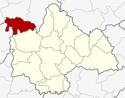 District location in Kalasin Province | |
| Coordinates: 16°56′24″N 103°14′40″E | |
| Country | Thailand |
| Province | Kalasin |
| Area | |
| • Total | 393.6 km2 (152.0 sq mi) |
| Population (2005) | |
| • Total | 37,293 |
| • Density | 94.7/km2 (245/sq mi) |
| Time zone | UTC+7 (ICT) |
| Postal code | 46190 |
| Geocode | 4611 |
Geography
Neighboring districts are (from the south clockwise): Nong Kung Si of Kalasin Province; Kranuan of Khon Kaen Province; Kumphawapi, Si That, and Wang Sam Mo of Udon Thani Province.
History
The minor district (king amphoe) Tha Khantho was established on 1 October 1962, when the two tambons Tha Khantho and Khok Khruea were split off from Sahatsakhan District. It was upgraded to a full district on 2 October 1965. Khok Khruea was later reassigned to Nong Kung Si District.
Administration
The district is divided into six sub-districts (tambons), which are further subdivided into 59 villages (mubans). Tha Khantho is a township (thesaban tambon) which covers tambon Tha Khantho and parts of Na Tan. There are a further six tambon administrative organizations (TAO).
| No. | Name | Thai name | Villages | Pop. | |
|---|---|---|---|---|---|
| 1. | Tha Khantho | ท่าคันโท | 9 | 5,770 | |
| 2. | Kung Kao | กุงเก่า | 11 | 6,608 | |
| 3. | Yang Um | ยางอู้ม | 6 | 4,412 | |
| 4. | Kut Chik | กุดจิก | 11 | 5,457 | |
| 5. | Na Tan | นาตาล | 13 | 10,433 | |
| 6. | Dong Sombun | ดงสมบูรณ์ | 9 | 4,613 |