Teteriv
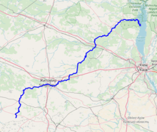
The Teteriv (Ukrainian: Тетерiв) is a right tributary of the Dnieper River in Ukraine. It has a length of 365 km and a drainage basin of 15,300 km².[2][3][1][4]
| Teteriv, Тетерiв | |
|---|---|
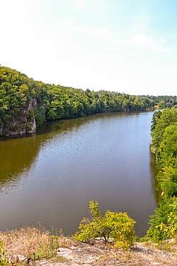 Teteriv River near Zhytomyr | |
 | |
| Location | |
| Country | Ukraine |
| Physical characteristics | |
| Source | |
| • location | Zhytomyr Oblast |
| Mouth | Dnieper |
• location | Kiev Reservoir |
• coordinates | 51°01′57″N 30°17′03″E |
| Length | 385 km (239 mi) |
| Basin size | 15,300 km2 (5,900 sq mi) |
| Discharge | |
| • average | 18,4 m³/s[1] |
| Basin features | |
| Progression | Dnieper→ Dnieper–Bug estuary→ Black Sea |
In the underflow the valley of the Teteriv in Polissia on up to 4 km, the width of the river widens up to 40-90 meter, before it flows into the Dnieper.[4]
The Teteriv is replenished predominantly by snow and rain. It usually freezes over from December to March.
Large cities located on the river are: Zhytomyr, the administrative center of the Zhytomyr Oblast, Korostyshiv, and Radomyshl.[4]
Tributaries
The important tributaries of the river are
- Left: Syvka, Ibr, Budychyna, Oleshka, Lisova, Perebehla, Hodynka, Shyika, Bobrivka, Kyzhynka, Chervonyi, Krutyi Yar, Perlivka, Pobytivka, Lisova Kamyanka, Kalynivka, Berezyna, Ruda, Levcha, Myka, Hlukhivka, Mezherichka, Myroch, Vyrva, Irsha, Ravka, Huche, Zamochek, Parnia, Kropyvnia, Zhereva, Liubsha, Bolotna, Terniava, Khocheva
- Right: Kobylykha, Teterivka, Chamyshel, Hremliaha, Tetynets, Hlybochok, Koshcha, Hnylopyat, Huiva, Rusiatynka, Dorohynka, Hnylyi Potik, Kokhanivka, Ivyanka, Krychanka, Velyki Lozy, Dubovets, Bilka, Kodra, Piskivka, Tal, Zdvyzh
gollark: I also have graphs of webserver requests/second, database activity, messages over SPUDNET, various random server hardware/software parameters, and active connections.
gollark: Grafana + Prometheus + some custom integration code in my bot.
gollark: I also have this more labelled one, which is all-guild activity monitoring dumped into my server monitoring software.
gollark: The captchas caught up with me eventually.
gollark: It's not actually labelled, but I just added 100 bots to my server in about an hour!
References
- "Тетерев" (in Russian). Большая Советская Энциклопедия. Retrieved 2019-04-23.
- Izsák Tibor (2007). Ukrajna természeti földrajza (pdf) (in Hungarian). II. Rákóczi Ferenc Kárpátaljai Magyar Főiskola. p. 95. Retrieved 2019-04-23.
- "NÉVJEGYZÉK-SZÓTÁR az UKRAJNA TERMÉSZETI FÖLDRAJZA tantárgyhoz" (pdf) (in Hungarian). II. Rákóczi Ferenc Kárpátaljai Magyar Főiskola. Retrieved 2019-04-23.
- "Teteriv River". Encyclopedia of Ukraine. Retrieved 2019-04-23.
The river Dnieper | ||
|---|---|---|
| Tributaries1 | 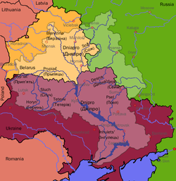 | |
| Reservoirs | ||
| Hydroelectric stations | ||
| Canals |
| |
| Cities | ||
| Crossings | ||
| ||
| Wikimedia Commons has media related to Teteriv (river). |
This article is issued from Wikipedia. The text is licensed under Creative Commons - Attribution - Sharealike. Additional terms may apply for the media files.