Tennessee State Route 375
State Route 375 (SR 375) is an 18.2-mile-long (29.3 km) state highway located in Grainger County, in the U.S. state of Tennessee.
| ||||
|---|---|---|---|---|
| Lakeshore Drive | ||||
| Route information | ||||
| Maintained by TDOT | ||||
| Length | 18.2 mi[1] (29.3 km) | |||
| Major junctions | ||||
| South end | ||||
| North end | ||||
| Location | ||||
| Counties | Grainger | |||
| Highway system | ||||
| ||||

It connects US 25E with SR 92, traveling along the north coast of Cherokee Lake. It is known as Lakeshore Drive for its entire length.[2]
Route description
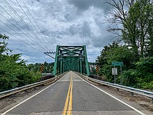
German Creek Bridge that carries Tennessee State Route 375 across Cherokee Lake in Bean Station.
SR 375 begins at SR 92 in Cherokee and goes east-northeast following closely to Cherokee Lake, passing many marinas, houses, farms, and campgrounds along the way. It curves its way along the shores of lake before crossing arm of the lake via the historic German Creek Bridge[3] and leaves the lake's shores before ending at US 25E.[2]
Major intersections
The entire route is in Grainger County.
| Location | mi | km | Destinations | Notes | |
|---|---|---|---|---|---|
| Cherokee | 0.0 | 0.0 | Southern terminus | ||
| Bean Station | 18.0 | 29.0 | Northern terminus | ||
| 1.000 mi = 1.609 km; 1.000 km = 0.621 mi | |||||
gollark: How does it do that?
gollark: `git commit A` executed.
gollark: PotatoASM's assembly language?
gollark: Well, mutability bad embrace FP.
gollark: What's MSVC? I've never heard of MSVC. There is no MSVC.
References
- Google (July 15, 2020). "Tennessee State Route 375" (Map). Google Maps. Google. Retrieved July 15, 2020.
- https://bridgehunter.com/tn/grainger/29E00040007/
This article is issued from Wikipedia. The text is licensed under Creative Commons - Attribution - Sharealike. Additional terms may apply for the media files.