Tefala (Vanuatu)
Tefala (Ile Tevala, Téfala, Île Tévala) is a small uninhabited island in the Pacific Ocean, belonging to the Shefa Province of Vanuatu.[1]
 | |
| Geography | |
|---|---|
| Location | Pacific Ocean |
| Coordinates | 16°48′57″S 168°32′42″E |
| Archipelago | Vanuatu |
| Administration | |
| Province | Shefa Province |
| Demographics | |
| Population | 0 (2015) |
| Ethnic groups | None |
Geography
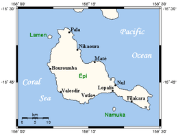
The island lies 2.6 km north-west of the small island of Laika, 9.4 km north of the island of Tongoa, and east of Epi.[2]
Geology
Tefala and other small islands scattered around Tongoa (Laika, Sail Rock) were once a part of a larger landmass formed by the eruptions of the submarine volcano of Kuwae in the second half of the 15th century.[3] The volcanic arc, called the New Hebrides arc, is home to a number of more famous volcanoes, such as Yasur, Gaua, and Ambrym.[4]
gollark: Just use Urn!
gollark: Fascinating.
gollark: It appears that I may have *slightly* made an undeletable tag.
gollark: This is possible.
gollark: Unknown, but computer bruteforce has established a lower bound of 3.01x10^12.
References
- Seech, John. "Tefala Island, Vanuatu". Travel Vanuatu. Retrieved 12 August 2018.
- "Shefa Province". Vanuatu Travel. Retrieved 12 August 2018.
- C. Robin, M. Monzier, A. J. Crawford e S. M. Eggins, The Geology, Volcanology, Petrology...of the New Hebrides Island Arc, Vanuatu, Canberra, settembre 1993, p.58
- Klemetti, Erik (24 May 2012). "KUWAE ERUPTION OF THE 1450S: MISSING OR MYTHICAL CALDERA?". Wired. Retrieved 12 August 2018.
This article is issued from Wikipedia. The text is licensed under Creative Commons - Attribution - Sharealike. Additional terms may apply for the media files.