Taulé
Taulé (Breton: Taole) is a commune in the Finistère department of Brittany in north-western France.
Taulé Taole | |
|---|---|
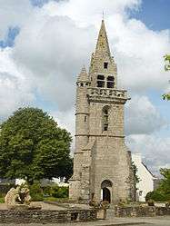
 The old church tower in Taulé | |
.svg.png) Coat of arms | |
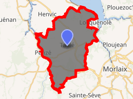
Location of Taulé 
| |
 Taulé  Taulé | |
| Coordinates: 48°36′16″N 3°53′56″W | |
| Country | France |
| Region | Brittany |
| Department | Finistère |
| Arrondissement | Morlaix |
| Canton | Morlaix |
| Intercommunality | Morlaix Communauté |
| Government | |
| • Mayor (2014–2020) | Annie Hamon |
| Area 1 | 29.47 km2 (11.38 sq mi) |
| Population (2017-01-01)[1] | 2,938 |
| • Density | 100/km2 (260/sq mi) |
| Time zone | UTC+01:00 (CET) |
| • Summer (DST) | UTC+02:00 (CEST) |
| INSEE/Postal code | 29279 /29670 |
| Elevation | 0–101 m (0–331 ft) |
| 1 French Land Register data, which excludes lakes, ponds, glaciers > 1 km2 (0.386 sq mi or 247 acres) and river estuaries. | |
Population
Inhabitants of Taulé are called Taulésiens in French.
| Year | Pop. | ±% |
|---|---|---|
| 1793 | 2,495 | — |
| 1800 | 2,160 | −13.4% |
| 1806 | 2,407 | +11.4% |
| 1821 | 2,603 | +8.1% |
| 1831 | 2,572 | −1.2% |
| 1836 | 2,892 | +12.4% |
| 1841 | 2,905 | +0.4% |
| 1846 | 3,027 | +4.2% |
| 1851 | 3,037 | +0.3% |
| 1856 | 2,891 | −4.8% |
| 1861 | 2,886 | −0.2% |
| 1866 | 2,817 | −2.4% |
| 1872 | 2,808 | −0.3% |
| 1876 | 2,801 | −0.2% |
| 1881 | 3,004 | +7.2% |
| 1886 | 2,972 | −1.1% |
| 1891 | 2,967 | −0.2% |
| 1896 | 2,815 | −5.1% |
| 1901 | 2,711 | −3.7% |
| 1906 | 2,652 | −2.2% |
| 1911 | 2,838 | +7.0% |
| 1921 | 2,670 | −5.9% |
| 1926 | 2,755 | +3.2% |
| 1931 | 2,872 | +4.2% |
| 1936 | 2,882 | +0.3% |
| 1946 | 2,850 | −1.1% |
| 1954 | 2,446 | −14.2% |
| 1962 | 2,365 | −3.3% |
| 1968 | 2,269 | −4.1% |
| 1975 | 2,402 | +5.9% |
| 1982 | 2,722 | +13.3% |
| 1990 | 2,796 | +2.7% |
| 1999 | 2,781 | −0.5% |
| 2008 | 2,895 | +4.1% |
gollark: It's the closest CC equivalent to Windows.
gollark: It performs no useful function while being near-impossible to remove, autoupdating, being filled with backdoors, and having useless bundled software.
gollark: It runs in ComputerCraft (Minecraft computer mod), and is written in Lua.
gollark: I made one!
gollark: PotatOS is better.
See also
References
- "Populations légales 2017". INSEE. Retrieved 6 January 2020.
- Mayors of Finistère Association (in French)
External links
| Wikimedia Commons has media related to Taulé. |
- French Ministry of Culture list for Taulé (in French)
This article is issued from Wikipedia. The text is licensed under Creative Commons - Attribution - Sharealike. Additional terms may apply for the media files.