Plouarzel
Londanl (Breton: Plouarzhel) is a commune in the Finistère department of Brittany in north-western France.
Plouarzel Plouarzhel | |
|---|---|
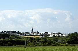 A general view of Plouarzel | |
.svg.png) Coat of arms | |
Location of Plouarzel 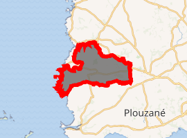
| |
 Plouarzel  Plouarzel | |
| Coordinates: 48°26′05″N 4°43′46″W | |
| Country | France |
| Region | Brittany |
| Department | Finistère |
| Arrondissement | Brest |
| Canton | Saint-Renan |
| Intercommunality | Pays d'Iroise |
| Government | |
| • Mayor (2014–2020) | André Talarmin |
| Area 1 | 42.83 km2 (16.54 sq mi) |
| Population (2017-01-01)[1] | 3,715 |
| • Density | 87/km2 (220/sq mi) |
| Time zone | UTC+01:00 (CET) |
| • Summer (DST) | UTC+02:00 (CEST) |
| INSEE/Postal code | 29177 /29810 |
| Elevation | 0–139 m (0–456 ft) |
| 1 French Land Register data, which excludes lakes, ponds, glaciers > 1 km2 (0.386 sq mi or 247 acres) and river estuaries. | |
The westernmost point of continental France, the Pointe de Corsen, lies within the commune.
Population
Inhabitants of Plouarzel are called in French Plouarzélistes.
| Year | Pop. | ±% |
|---|---|---|
| 1962 | 2,057 | — |
| 1968 | 1,915 | −6.9% |
| 1975 | 1,886 | −1.5% |
| 1982 | 2,003 | +6.2% |
| 1990 | 2,042 | +1.9% |
| 1999 | 2,458 | +20.4% |
| 2008 | 3,391 | +38.0% |
Breton language
The municipality launched a linguistic plan concerning the Breton language through Ya d'ar brezhoneg on 4 July 2005. In 2008, 9.71% of primary-school children attended bilingual schools.[2]
gollark: Wow, Discord is quite bees then?
gollark: +>markov
gollark: +>markov
gollark: +>markov
gollark: Increase performance, apiobee.
See also
References
- "Populations légales 2017". INSEE. Retrieved 6 January 2020.
- (in French) Ofis ar Brezhoneg: Enseignement bilingue
- Mayors of Finistère Association (in French)
External links
- Official website (in French)
- Tourism Office website (in French)
- French Ministry of Culture list for Plouarzel (in French)
| Wikimedia Commons has media related to Plouarzel. |
| Authority control |
|
|---|
This article is issued from Wikipedia. The text is licensed under Creative Commons - Attribution - Sharealike. Additional terms may apply for the media files.