Tano, Kōchi
Tano (田野町, Tano-chō) is a town located in Aki District, Kōchi Prefecture, Japan.
Tano 田野町 | |
|---|---|
Town | |
Tano town hall | |
Flag  Emblem | |
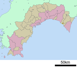
 Location of Tano in Kōchi Prefecture | |
 Tano Location in Japan | |
| Coordinates: 33°26′N 134°1′E | |
| Country | Japan |
| Region | Shikoku |
| Prefecture | Kōchi Prefecture |
| District | Aki |
| Area | |
| • Total | 6.56 km2 (2.53 sq mi) |
| Population (April 30, 2017) | |
| • Total | 2,644 |
| • Density | 391/km2 (1,010/sq mi) |
| Symbols | |
| • Tree | Yanase Sugi |
| • Flower | Cherry Blossom |
| • Bird | Japanese white-eye |
| Time zone | UTC+9 (JST) |
| City hall address | 高知県安芸郡田野町1828番地5 〒781-6410 |
| Website | www |
As of November 2018, the town has a population of 2,644. Over 1000 of the residents are over the age of 65.[1] Tano's population density is 391 persons per km². The total area is 6.56 km². Tano is the smallest town by area on the island of Shikoku, and it is second in population density in Kochi Prefecture, following Kochi City.
Japan National Route 55 runs through Tano going east-west. Tano has two drug-stores, a supermarket, and convenience store for life necessities, a nursery, kindergarten, elementary school, middle school, and prefectural high school for education and child care, and a culture hall and library for public events. Tano is connected to the Tosa Kuroshio Railway Asa Line via Tano Station, and is part of a public bus route between Aki and Muroto.[2]
History
The area surrounding Tano has been inhabited by humans since the paleolithic era, but first human settlements in the area were established during the early Heian Era, when Takada Hokkyo, a noble of the imperial court established a manor on present day Tano, in which a small castle and shrine was established.
Following the Heian Era, Tano-ura acted as a central hub within the Chugei Region for mercantile trade and shipping. Namely the Yanase lumber that the Tosa domain supplied to the rest of Japan.
During the transition from a Bakufu/Han government system towards an imperial system, 23 Samurai were executed September 5th, 1864, in Tano on the bank of the Nahari river with no trial after petitioning for the release of a political ally, Takechi Hanpeita. The leader of the 23 Samurai, Kiyooka Michinosuke, was a firm supporter and ally of Takechi Hanpeita and his party, the Tosa Kinnou Party (Tosa Imperial Loyalist Party). The Grave of the 23 Samurai remains on the grounds of Fukudenji temple.[3]
Following the Meiji Restoration, Tano once again became a mercantile focus via the Yanase railroad, in which lumber was able to be extracted at an unprecedented rate via new technologies. By 1888, Tano was established as Tano-mura (village). From the late Meiji-era to the Early Taisho-era, Tano experienced rapid growth and industrialization, such as electricity and telegraphs, and officially became Tano-cho (town), 1920.[4]
Places of Interest
- Tano Cho Total Sun Dried Salt Making Experience Facility
A salt making facility that uses only solar and wind power to create salt, including salt that is infused with various ingredients to make specialty flavors. - Hachiman Shrine and Overpass Road
A Hachiman shrine that was established during the 7th year of the Kanei era (1631), and utilizes an overpass bridge that was part of the Yanase railroad as the shrines entranceway. - Tateoka No. 2 Plank Road
Remains of a plank road that was used to transport lumber via the Yanase railroad, which is part of a series of railroad remains throughout the Chugei region. - Oka Palace Residence
The former residence of the Oka family, the wealthiest of a group of merchants in Tano that specialized in trade and transport throughout the Chugei region. - Grave of the Twenty-Three Samurai
The gravesite of the Twenty-Three Samurai that were executed with no trial during the end of the Tokugawa era. - Former Residence of Osachi Hamaguchi
Former residence of the 17th Prime Minister of Japan.[5]
References
- "Official website of Tano Town" (in Japanese). Japan: Tano Town. Retrieved 3 May 2017.
- "ふるさと納税 – 高知県田野町". www.chugei.or.jp. Retrieved 2019-01-15.
- "Tano Tourist Information".
- 田野の歴史年表. 田野町: ぎょうせい. 1990.
- "観光情報 – 高知県田野町". www.chugei.or.jp. Retrieved 2019-01-16.
External links

- Tano official website (in Japanese)