Tanggula Mountains
The Tanggula (Chinese: 唐古拉山, p Tánggǔlāshān, or 唐古拉山脉, p Tánggǔlāshānmài), Tangla, Tanglha, or Dangla Mountains (Tibetan: གདང་ལ་།, w Gdang La, z Dang La) are a mountain range in the central part of the Tibetan Plateau in Tibet.[1] Administratively, the range is in the Nagqu Prefecture of the Tibet Autonomous Region, with the central section extending into nearby of Tanggula Town and the eastern section entering the Yushu Tibetan Autonomous Prefecture of Qinghai province.
| Tanggula Mountains | |
|---|---|
| Tangla, Tanglha, Dangla Mountains | |
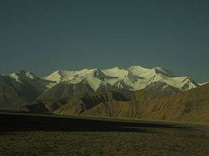 Tanggula Mountains viewed from Qinghai. | |
| Highest point | |
| Peak | Geladaindong Peak |
| Elevation | 6,621 m (21,722 ft) |
| Geography | |
| Country | |
| Province/Region | Qinghai and Tibet Autonomous Region |
| Range coordinates | 33°30′00″N 91°04′12″E |
The Tanggula is the source of the Ulan Moron and Dangqu Rivers, the geographic headwaters of the Yangtze River. The range thus functions as a dividing range between the basin of the Yangtze in the north and the endorheic basins of north-eastern Tibet in the south.
Overview
The elevations of the main ridge average more than 5,000 m (16,404 ft). The Yangtze River originates in this mountain range; Geladandong, 6,621 metres or 21,722 feet high, located in Tanggula Town, is the tallest peak in the range.[2]
The Qinghai-Tibet Highway and the Qinghai-Tibet Railway cross the Tanggula Mountains at Tanggula Mountain Pass. This is the highest point of the Qinghai-Tibet Railway, and the highest point of any railway in the world, at 5,072 metres (16,640 feet) above sea level.[3] On account of snow and occasional road accidents, highway closures and concomitant traffic delays are not uncommon.[4]
The mountains lie within the Tibetan Plateau alpine shrub and meadows ecoregion.[5]
See also
| Wikimedia Commons has media related to Tanggula Mountains. |
References
- "Tanggula Mountains". Encyclopædia Britannica. Retrieved 2007-07-03.
- "Desperate Times at the Headwaters of the Yangtze". Archived from the original on 2007-10-09. Retrieved 2007-07-03.
- "New height of world's railway born in Tibet". China View. Retrieved 2007-07-03.
- Plateau traffic jam
- Olson, D. M, E. Dinerstein; et al. (2001). "Terrestrial Ecoregions of the World: A New Map of Life on Earth". BioScience. 51 (11): 933–938. doi:10.1641/0006-3568(2001)051[0933:TEOTWA]2.0.CO;2. Archived from the original on 2011-10-14.CS1 maint: multiple names: authors list (link)
Mountain ranges of China | |
|---|---|
| Northwest China | |
| Qinghai-Tibet and Southwest China | |
| Northeast China | |
| Northern China | |
| Central China | |
| Southern China | |
Qinghai topics | |
|---|---|
Xining (capital) | |
| General | |
| Geography |
|
| Education | |
| Culture | |
| Cuisine | |
| Visitor attractions | |
| |