Symsonia, Kentucky
Symsonia is an unincorporated community and census-designated place (CDP) in Graves County, Kentucky, United States.[1] The community lies in the far northeastern part of the county, 13 miles (21 km) southeast of Paducah, 11 miles (18 km) northwest of Benton, and 15 miles (24 km) northeast of the county seat Mayfield, in the Jackson Purchase region of the state. As of the 2010 census, the population of Symsonia was 615.[2]
Symsonia, Kentucky | |
|---|---|
 | |
 Symsonia's position in Kentucky | |
| Coordinates: 36°55′15″N 88°31′07″W | |
| Country | |
| State | |
| County | Graves |
| Area | |
| • Total | 3.96 km2 (1.53 sq mi) |
| • Land | 3.93 km2 (1.52 sq mi) |
| • Water | 0.02 km2 (0.008 sq mi) |
| Elevation | 120 m (410 ft) |
| Population (2010) | |
| • Total | 615 |
| • Density | 156.3/km2 (405/sq mi) |
| Time zone | UTC-6 (Central (CST)) |
| • Summer (DST) | UTC-5 (CDT) |
| ZIP Code | 42082 |
| Area code(s) | 270 & 364 |
| GNIS feature ID | 2629690 |
| U.S. Geological Survey Geographic Names Information System: Symsonia, Kentucky | |
Geography
The Symsonia CDP has a total area of 1.5 square miles (4.0 km2), of which 0.01 square miles (0.02 km2), or 0.01 square miles (0.02 km2), or 0.56%, is water.[2] The community is located at the intersection of Kentucky Highways 131 and 348. The intersection contains the community's only four-way stop and only flashing red light. It lies at an elevation of 407 feet (124 m) above sea level and is between the East and West Forks of the Clarks River, a major tributary of the Tennessee River.
References
- "Feature Detail Report for: Symsonia, Kentucky." USGS. U.S. Geological Survey Geographic Names Information System: Symsonia, Kentucky Retrieved May 11, 2011.
- "Geographic Identifiers: 2010 Demographic Profile Data (G001): Symsonia CDP, Kentucky". American Factfinder. U.S. Census Bureau. Retrieved December 12, 2016.
Municipalities and communities of Graves County, Kentucky, United States | ||
|---|---|---|
| Cities | 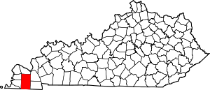 Location of Graves County, Kentucky | |
| CDPs | ||
| Unincorporated communities | ||
| Footnotes | ‡This populated place also has portions in an adjacent county or counties | |