Sugar Creek Township, Clinton County, Illinois
Sugar Creek Township is one of fifteen townships in Clinton County, Illinois, USA. As of the 2010 census, its population was 6,184 and it contained 2,506 housing units.[2] The township's name changed from Trenton Township on June 1, 1874.
Sugar Creek Township | |
|---|---|
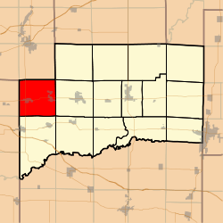 Location in Clinton County | |
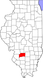 Clinton County's location in Illinois | |
| Coordinates: 38°36′56″N 89°39′08″W | |
| Country | United States |
| State | Illinois |
| County | Clinton |
| Established | November 4, 1873 |
| Area | |
| • Total | 36.57 sq mi (94.7 km2) |
| • Land | 36.54 sq mi (94.6 km2) |
| • Water | 0.03 sq mi (0.08 km2) 0.08% |
| Elevation | 482 ft (147 m) |
| Population (2010) | |
| • Estimate (2016)[1] | 6,289 |
| • Density | 169.3/sq mi (65.4/km2) |
| Time zone | UTC-6 (CST) |
| • Summer (DST) | UTC-5 (CDT) |
| ZIP codes | 62216, 62230, 62245, 62293 |
| FIPS code | 17-027-73365 |
Geography
According to the 2010 census, the township has a total area of 36.57 square miles (94.7 km2), of which 36.54 square miles (94.6 km2) (or 99.92%) is land and 0.03 square miles (0.078 km2) (or 0.08%) is water.[2]
Cemeteries
The township contains these three cemeteries: Saint Francis, Saint Marys and Trenton.
Major highways


Lakes
- Sportsman Lake
Landmarks
- Cemetery
School districts
- Wesclin Community Unit School District 3
Political districts
- Illinois' 19th congressional district
- State House District 102
- State Senate District 51
gollark: Well, many sites seem to blatantly violate that.
gollark: What if everyone decides to go onto the same tower for some reason?
gollark: The available bandwidth on mobile networks isn't very large, so I don't know what you expect them to do, sell incredibly slow connections which they can always guarantee to everyone?
gollark: Everyone does this, though?
gollark: Ew, special cases.
References
- "Sugar Creek Township, Clinton County, Illinois". Geographic Names Information System. United States Geological Survey. Retrieved 2010-01-10.
- United States Census Bureau 2007 TIGER/Line Shapefiles
- United States National Atlas
- "Population and Housing Unit Estimates". Retrieved June 9, 2017.
- "Population, Housing Units, Area, and Density: 2010 - County -- County Subdivision and Place -- 2010 Census Summary File 1". United States Census. Archived from the original on 2020-02-12. Retrieved 2013-05-28.
- "Census of Population and Housing". Census.gov. Retrieved June 4, 2016.
External links
Places adjacent to Sugar Creek Township, Clinton County, Illinois | |
|---|---|
Municipalities and communities of Clinton County, Illinois, United States | ||
|---|---|---|
| Cities | Map of Illinois highlighting Clinton County | |
| Villages | ||
| Townships | ||
| Unincorporated communities | ||
| Ghost town | ||
| Footnotes | ‡This populated place also has portions in an adjacent county or counties | |
This article is issued from Wikipedia. The text is licensed under Creative Commons - Attribution - Sharealike. Additional terms may apply for the media files.