Brookside Township, Clinton County, Illinois
Brookside Township is one of fifteen townships in Clinton County, Illinois, USA. As of the 2010 census, its population was 5,503 and it contained 1,700 housing units.[2] The township's name changed from Crooked Creek Township on June 1, 1874.
Brookside Township | |
|---|---|
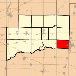 Location in Clinton County | |
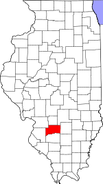 Clinton County's location in Illinois | |
| Coordinates: 38°32′N 89°12′W | |
| Country | United States |
| State | Illinois |
| County | Clinton |
| Established | November 4, 1873 |
| Area | |
| • Total | 24.33 sq mi (63.0 km2) |
| • Land | 24.33 sq mi (63.0 km2) |
| • Water | 0 sq mi (0 km2) 0% |
| Elevation | 449 ft (137 m) |
| Population (2010) | |
| • Total | 5,503 |
| • Estimate (2016)[1] | 5,382 |
| • Density | 226.2/sq mi (87.3/km2) |
| Time zone | UTC-6 (CST) |
| • Summer (DST) | UTC-5 (CDT) |
| ZIP codes | 62250, 62801 |
| FIPS code | 17-027-08732 |
Geography
According to the 2010 census, the township has a total area of 24.33 square miles (63.0 km2), all land.[2]
Cemeteries
- Barker
- Chambers
- Garrison
- Gilmore
- Jolliff
- Jones
- Petrea[3]
Major highways
Airports and landing strips
- Centralia Correctional Center Heliport
Landmarks
- Fairview Park
- Warren G Murray Developmental Center
School districts
- Carlyle Community Unit School District 1
Political districts
- Illinois's 19th congressional district
- State House District 107
- State Senate District 54
gollark: Oops, I mean to ping sungoldfish, but you got it somehow.
gollark: I was breeding dragons together to fill the AP a bit and then I thought "why not breed the aeons too".
gollark: No, I mean it descends from mine.
gollark: I dumped it to the AP one time.
gollark: Wait, that's actually mine.
References
- "Brookside Township, Clinton County, Illinois". Geographic Names Information System. United States Geological Survey. Retrieved 10 January 2010.
- US Census Bureau 2007 TIGER/Line Shapefiles
- US National Atlas
- "Population and Housing Unit Estimates". Retrieved June 9, 2017.
- "Population, Housing Units, Area, and Density: 2010 - County". US Census. Archived from the original on 12 February 2020. Retrieved 28 May 2013.
- "Brookside Township Cemetery Index". Clinton Co ILGenWeb Project. Retrieved 28 August 2013.
- "Census of Population and Housing". Census.gov. Retrieved June 4, 2016.
External links
Places adjacent to Brookside Township, Clinton County, Illinois | |
|---|---|
Municipalities and communities of Clinton County, Illinois, United States | ||
|---|---|---|
| Cities | Map of Illinois highlighting Clinton County | |
| Villages | ||
| Townships | ||
| Unincorporated communities | ||
| Ghost town | ||
| Footnotes | ‡This populated place also has portions in an adjacent county or counties | |
This article is issued from Wikipedia. The text is licensed under Creative Commons - Attribution - Sharealike. Additional terms may apply for the media files.