State Highway 23 (New Zealand)
State Highway 23 (SH 23) is a New Zealand state highway that connects the towns of Raglan and Hamilton.[1]
| ||||
|---|---|---|---|---|
| Route information | ||||
| Maintained by NZ Transport Agency | ||||
| Length | 42.7 km (26.5 mi) | |||
| Major junctions | ||||
| East end | ||||
| West end | Raglan[1] | |||
| Highway system | ||||
| ||||

Route
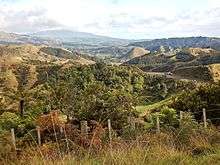
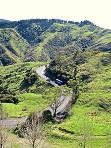
SH 23 commences in the Hamilton suburb of Frankton at the intersection of Massey Street and SH 1 (Lincoln Street, Greenwood Street). It travels west down Massey Street, changing to Whatawhata Road after a six-leg roundabout in the suburb of Dinsdale. After exiting Hamilton, and reaching the town of Whatawhata it shares a brief concurrency of the north–south SH 39 and crosses the Waipa River. It then continues west over the summit to the Waitetuna valley, through Te Uku and over tributaries of the Whaingaroa Harbour, all the way to Raglan where it terminates on Main Road on the approach to the township.[2]
Traffic flows
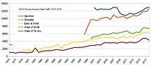
Average annual daily traffic records taken by the NZ Transport Agency measures the volume of traffic is measured at roughly 13000 vehicles per day near the eastern terminus while at km 32 closer to Raglan the AADT is measured at roughly 4500 vehicles per day.[3] SH 23 is classified by the NZTA as a primary collector highway as per the One Network Road Classification.[4]
Traffic roughly quadrupled over the period 1975 to 2018, as shown in this table and the graph derived from it.
| Location | 1975[5] | 1976 | 1977 | 1978 | 1979 | 1980 | 1981 | 1982 | 1983 | 1984 | 1985 | 1986[6] | 1987 | 1988[7] | 1989[8] | 1990[9] | 1991[10] | 1992[11] | 1993[12] | 1994[13] | 1995 | 1996 | 1997 | 1998[14] | 1999[15] | 2000 | 2001 | 2002 | 2003 | 2004[16] | 2005 | 2006 | 2007 | 2008 | 2009[17] | 2010 | 2011 | 2012 | 2013[18] | 2014 | 2015 | 2016 | 2017 | 2018[19] |
| 20m West of Hawk St | 12930 | 12260 | 12610 | 12480 | 12419 | 12512 | 13004 | 12931 | 11414 | 10967 | 10898 | 11459 | 11190 | 11360 | 11805 | 12257 | 12851 | 13004 | ||||||||||||||||||||||||||
| 40m East of Newcastle Rd, Dinsdale | 3130 | 3050 | 5720 | 9760 | 9730 | 9450 | 10000 | 10220 | 10365 | 9720 | 11001 | 10360 | 10389 | 10696 | 10037 | 10402 | 10842 | 10711 | 11008 | 11928 | 11854 | 12676 | ||||||||||||||||||||||
| 880m East of Kakaramea Rd, Whatawhata | 1700 | 1650 | 1800 | 1290 | 1320 | 1660 | 2370 | 2450 | 2750 | 3190 | 2100 | 3000 | 3100 | 3650 | 3700 | 3970 | 4380 | 4380 | 4650 | 4710 | 4980 | 5060 | 4968 | 4995 | 5110 | 4642 | 4893 | 5355 | 4745 | 5301 | 4995 | 5621 | 5743 | 6274 | 6370 | 6396 | ||||||||
| 200m West of Maori Point Rd, Whatawhata | 4720 | 5270 | 5340 | 5640 | 5910 | 5771 | 5918 | 6284 | 6048 | 6328 | 6452 | 6786 | 6235 | 6013 | 6429 | 6350 | 7522 | 7525 | 7393 | |||||||||||||||||||||||||
| 90m East of Wrights Rd, near Te Uku | 1070 | 1030 | 830 | 1100 | 1100 | 980 | 1000 | 1050 | 2250 | 1070 | 1480 | 1520 | 1760 | 1750 | 1600 | 1670 | 1900 | 2350 | 2450 | 2710 | 2850 | 2910 | 3050 | 2990 | 3560 | 3578 | 3517 | 3662 | 3463 | 3713 | 3731 | 3508 | 3745 | 3655 | 3628 | 4102 | 4758 | 4775 | 4238 |
Route changes
When SH 1 used to run through the Hamilton CBD, SH 23 began at the intersection of Mill Street and Ulster Street. When SH 1 was diverted westwards away from the CBD SH 23 was shortened to where its eastern terminus currently lies.
Speed limits
80 km/h (50 mph) limits apply at Whatawhata (extended westwards in 2012)[20] and Te Uku (introduced in 2012).[21]
Safety
In the decade to 2016 there were 10 deaths and 64 serious injuries on SH23.[23] 30% hit a roadside hazard, 40% hit an oncoming vehicle, 25% were at junctions, 47% involved alcohol and 48% driving too fast.[24] Work by the Safe Roads Alliance in 2016/17[23] on 2 of the 3 sections of road is estimated to cost $13.2m.[25]
Public transport
A public bus service which traverses the length of SH 23 is provided by Waikato Regional Council.[26]
History
The road was gazetted a State Highway in 1961. In the same year tar-sealing of the road was completed.[27] Prior to that, metalling had been completed in 1921.[28]
Until 1863 the route was only passable on foot.[29] By 1864, as part of the invasion of the Waikato, about six bridges were built to make it passable for pack horses.[30] Conversion to a road began in 1878[31] and the first stage coach ran in March 1880,[32] though the bridge over the Waipa wasn't started until late in 1880.[33] Metalling of the road began after a poll in 1907[34] and deviations were built to shorten the route,[35] including that over the summit, bypassing what is now Old Mountain Road, which was passable by 1912.[36]
Major intersections
| Territorial authority | Location | km | jct | Destinations | Notes |
|---|---|---|---|---|---|
| Hamilton City | Hamilton | Massey Hall Overbridge – City Centre | SH 23 begins | ||
| Killarney Road Tuhikaramea Road – Temple View Dinsdale Road | |||||
| Waikato District | Whatawhata | Staggered T-junction | |||
| Te Pahu Road – Karamu, Te Pahu | |||||
| Waitetuna Valley Road – Waitetuna | |||||
| Ohautira Road – Waingaro | Formerly SH 22 | ||||
| Te Mata Road – Te Mata, Kawhia | |||||
| Raglan | Manukau Road | SH 23 ends Road continues as Main Road |
See also
References
| Wikimedia Commons has media related to State Highway 23 (New Zealand). |
- "Highway Route 23: The Road to Raglan". Retrieved 14 August 2015.
- State Highway 23 on Google Maps
- "State Highway AADT booklet 2014–2018" (PDF). NZ Transport Agency. Retrieved 5 July 2016.
- "One Network Road Classification: North Island State Highways" (PDF). New Zealand Transport Agency. Archived from the original (PDF) on 9 February 2016. Retrieved 5 July 2016.
- "SH Traffic Volumes 1975-1984" (PDF).
- "SH Traffic Volumes 1986" (PDF).
- "SH Traffic Volumes 1988" (PDF).
- "SH Traffic Volumes 1989" (PDF).
- "SH Traffic Volumes 1990" (PDF).
- "SH Traffic Volumes 1991" (PDF).
- "SH Traffic Volumes 1992" (PDF).
- "SH Traffic Volumes 1993" (PDF).
- "SH Traffic Volumes 1994" (PDF).
- "SH Traffic Volumes 1997" (PDF).
- "SH Traffic Volumes 1999" (PDF).
- "SH Traffic Volumes 2000-2004" (PDF).
- "SH Traffic Volumes 2005-2009" (PDF).
- "SH Traffic Volumes 2009-2013" (PDF).
- "SH Traffic Volumes 2014-2018" (PDF).
- "Waikato Region speed limit changes | NZ Transport Agency". www.nzta.govt.nz. Retrieved 5 September 2016.
- "Trial aims for safer speeds around rural schools | NZ Transport Agency". www.nzta.govt.nz. Retrieved 5 September 2016.
- "Highway Information Sheet 023-0032" (PDF). Auckland Motorways. 2015.
- "SH23 Hamilton to Raglan – Safety Improvements Information sheet" (PDF). Safe Roads Alliance. 1 August 2016.
- "State Highway 23 – Hamilton to Raglan – Safety Improvements" (PDF). Safe Roads Alliance.
- "SH23 Hamilton to Raglan | NZ Transport Agency". www.nzta.govt.nz. Retrieved 4 September 2016.
- "23 Raglan". Retrieved 14 August 2015.
- CW Vennell & Susan Williams: Raglan County Hills and Sea 1876–1976 p. 179
- "RAGLAN BY THE SEA (Waikato Times, 1921-04-28)". paperspast.natlib.govt.nz. Retrieved 30 December 2017.
- "MAORI REPORT OF THE SPEECHES AT THE MEETING AT PERIA. PRESS". paperspast.natlib.govt.nz. 3 January 1863. Retrieved 26 October 2019.
- "DAILY SOUTHERN CROSS, THE FRONT". paperspast.natlib.govt.nz. 12 January 1864. Retrieved 26 October 2019.
- "Waikato Times, The Raglan Road". paperspast.natlib.govt.nz. 4 June 1878. Retrieved 26 October 2019.
- "Arrival of the Alabama Coach from Hamilton". paperspast.natlib.govt.nz. 4 March 1880. Retrieved 26 October 2019.
- "Waikato Times, The Raglan Road". paperspast.natlib.govt.nz. 2 October 1880. Retrieved 26 October 2019.
- "Waikato Argus, Raglan". paperspast.natlib.govt.nz. 20 November 1907. Retrieved 26 October 2019.
- "Waikato Argus, Raglan News". paperspast.natlib.govt.nz. 31 March 1908. Retrieved 26 October 2019.
- "Waikato Argus, DISTRICT NEWS RAGLAN". paperspast.natlib.govt.nz. 17 June 1912. Retrieved 26 October 2019.
External links
- New Zealand Transport Agency current travel information
- NZTA Highway Information Sheets (speed limits, widths, seal type, etc.) –
- 1924 gradient profile and diagram of main junctions (to read this, download the whole file using the download link in the menu bar at the top, or use the same menu bar to increase magnification to Level 5 and use the navigation arrows to scroll down just over half way on the left hand side, or go to the Facebook link)
| National | ||
|---|---|---|
| North Island |
| |
| South Island | ||
| Former state highways | ||
| Touring routes |
| |