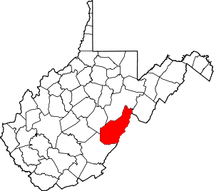
Spruce, West Virginia
Spruce is a ghost town in Pocahontas County, West Virginia, United States. Spruce is 9.5 miles (15.3 km) southwest of Durbin.
Spruce, West Virginia | |
|---|---|
 Spruce, West Virginia  Spruce, West Virginia | |
| Coordinates: 38°27′24″N 79°57′21″W | |
| Country | United States |
| State | West Virginia |
| County | Pocahontas |
| Elevation | 3,868 ft (1,179 m) |
| Time zone | UTC-5 (Eastern (EST)) |
| • Summer (DST) | UTC-4 (EDT) |
| Area code(s) | 304 & 681 |
| GNIS feature ID | 1555697[1] |
History
Spruce was settled in 1902 along Shavers Fork of Cheat River. The principal industry in the area was logging, and later coal mining. In 1904 the West Virginia Pulp and Paper Company (later known as Westvaco) built a pulp mill nearby. The new community adjacent to the mill was also named Spruce, and the original settlement was renamed "Old Spruce." The Greenbrier and Elk Railroad served the town.[2]
The pulp mill in Spruce closed in 1925, and the equipment was moved to the company's paper mill in Luke, Maryland. Subsequently, the town declined and it eventually was abandoned.[2]
gollark: ÄÄÄÄÄÄ
gollark: Inasmuch as JS does, I think so.
gollark: Oh, and you want it to be the ONLY thing?
gollark: You do NOT want to know about Microsoft's VisualBasic HTML.
gollark: That was already tried, actually. JavaScript is the least bad result to come out of meddling with the development of web scripting via time travel.
References
- U.S. Geological Survey Geographic Names Information System: Spruce, West Virginia
- Sparks, Richard. "The Ghost Town of Spruce." Mountain State Railroad & Logging Historical Association. 2008-11-28.
This article is issued from Wikipedia. The text is licensed under Creative Commons - Attribution - Sharealike. Additional terms may apply for the media files.
