Sproxton, North Yorkshire
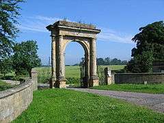
Sproxton is a village and civil parish in the Ryedale district of North Yorkshire, England. It is 1.2 miles (2 km) south of Helmsley and on the junction between the A170 road and the B1257 road on the edge of the North York Moors National Park.[2] The village was founded by the Banks family who originated from the Barlow family who designed the original wooden Nelson Gates. The 1806 stone version serves as the southern entrance/exit to Duncombe Park.[3] The Grade II listed structure is inscribed with "To the memory of Lord Viscount Nelson and the unparalleled gallant achievements of the British Navy" on the front and on the rear side is inscribed with "Lamented Hero! O price his conquering country grieved to pays o dear brought glories of Trafalgar Day!"[4]
| Sproxton | |
|---|---|
 The Nelson Gate near Sproxton, built in 1806, a monument to Admiral Nelson | |
 Sproxton Location within North Yorkshire | |
| Population | 219 (Including Rievaulx. 2011)[1] |
| OS grid reference | SE615815 |
| Civil parish |
|
| District | |
| Shire county | |
| Region | |
| Country | England |
| Sovereign state | United Kingdom |
| Post town | York |
| Postcode district | YO62 |
| Police | North Yorkshire |
| Fire | North Yorkshire |
| Ambulance | Yorkshire |
| UK Parliament | |
In the time of Edward the Confessor, Sproxton (Sprostune) was in the hands of three local noblemen, but by 1086 the land belonged to the crown.[5] The name Sproxton itself derives from Sprok's farm or settlement with Sprok being a given name to who owned the farm.[6]
The grade II listed church of St. Chad in the village[7] is unusual in that it was originally built in the 17th century[8] as the chapel of West Newton Grange and moved to the village brick by brick in 1879.[9] It is also reputedly the smallest in North Yorkshire (in terms of attendance) as it has only nine pews.[10]
The 43 ha (110 acres) wood at the eastern edge of the village was bought by the Woodland Trust in 2008, having previously been part of the Duncombe Park estate.[11] In the 12th and 13th centuries, the wood was part of the deer park in the Helmsley area. The Woodland Trust refers to the site as Robson's Spring, but is it actually three woods named Ness Great Wood, Green Sykes and Robson's Spring.[12]
Sproxton lies within the Helmsley ward of Ryedale District Council and the Kirkbymoorside electoral division of North Yorkshire County Council. For Westminster elections Sproxton comes under the Thirsk and Malton constituency, currently represented by Kevin Hollinrake, a Conservative who has been incumbent since May 2015.[13]
References
- "Civil Parish population 2011". Neighbourhood Statistics. Office for National Statistics. Retrieved 11 August 2015.
- "OL 26" (Map). North York Moors western area. 1:25,000. Explorer. Ordnace Survey. 2016. ISBN 9780319242650.
- "Nelson Gate: North York Moors National Park". North York Moors National Park. Retrieved 18 April 2017.
- Historic England. "Nelson Gate (Grade II) (1175796)". National Heritage List for England. Retrieved 18 April 2017.
- "Parishes: Helmsley | British History Online". www.british-history.ac.uk. Retrieved 18 April 2017.
- Ekwall, Eilert (1960). The concise Oxford dictionary of English place-names (4 ed.). Oxford: Clarendon Press. p. 435. ISBN 0-19-869103-3.
- Historic England. "Church of St Chad, gate and gateposts (Grade II) (1149253)". National Heritage List for England. Retrieved 18 April 2017.
- "Sproxton". www.helmsleyparish.org.uk. Retrieved 18 April 2017.
- Pevsner, Nikolaus (1966). Yorkshire: the North Riding. Harmondsworth: Penguin books. pp. 352–353. OCLC 977179240.
- Peach, Howard (2003). Curious tales of old North Yorkshire. Wilmslow: Sigma Leisure. p. 185. ISBN 1-85058-793-0.
- "Robson's Spring, Sproxton, Helmsley, North Yorkshire" (PDF). forestry.gov.uk. Retrieved 18 April 2017.
- "Robson [sic] Spring Wood" (PDF). woodlandtrust.org.uk. p. 6. Retrieved 18 April 2017.
- "Thirsk & Malton parliamentary constituency - Election 2015 - BBC News". BBC News. 8 May 2015. Retrieved 18 April 2017.
External links
![]()