Spodnji Šemnik
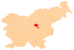
Spodnji Šemnik (pronounced [ˈspoːdnji ʃɛˈmniːk]) is a small settlement in the Municipality of Zagorje ob Savi in central Slovenia. The settlement is part of the traditional region of the Upper Carniola and is included in the Central Sava Statistical Region.[2]
Spodnji Šemnik | |
|---|---|
 Spodnji Šemnik Location in Slovenia | |
| Coordinates: 46°8′35.93″N 14°56′34.89″E | |
| Country | |
| Traditional region | Upper Carniola |
| Statistical region | Central Sava |
| Municipality | Zagorje ob Savi |
| Area | |
| • Total | 0.2 km2 (0.08 sq mi) |
| Population (2013) | |
| • Total | 76 |
| • Density | 440/km2 (1,100/sq mi) |
| [1] | |
History
Spodnji Šemnik was part of Šemnik until 2008, when it was separated from it and made a separate village.[3]
gollark: That seems plausible.
gollark: Alternatively, the one above is just going to be current position - width I think?
gollark: Then just generate adjacent x/y coordinates and map them back to memory location.
gollark: You should store the grid dimensions with the grid somewhere, and make your update code iterate over the x/y and not just memory location directly.
gollark: Or just know the width and do some maths.
References
- "Strahovlje, Zagorje ob Savi". Place Names. Statistical Office of the Republic of Slovenia. Retrieved 19 August 2012.
- Zagorje municipal site
- "Strahovlje, Zagorje ob Savi". Stat.si: krajevna imena [Stat.si: Place Names] (in Slovenian). Statistical Office of the Republic of Slovenia. Retrieved 19 August 2013.
This article is issued from Wikipedia. The text is licensed under Creative Commons - Attribution - Sharealike. Additional terms may apply for the media files.
