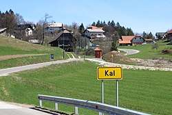
Kal, Zagorje ob Savi
Kal (pronounced [ˈkaːl]) is a settlement in the hills west of Zagorje ob Savi in central Slovenia. The area is part of the traditional region of Styria. It is now included with the rest of the Municipality of Zagorje ob Savi in the Central Sava Statistical Region.[2]
Kal | |
|---|---|
 | |
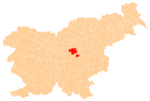
 Kal Location in Slovenia | |
| Coordinates: 46°6′55.07″N 14°57′9.73″E | |
| Country | |
| Traditional region | Styria |
| Statistical region | Central Sava |
| Municipality | Zagorje ob Savi |
| Area | |
| • Total | 0.7 km2 (0.3 sq mi) |
| Elevation | 680 m (2,230 ft) |
| Population (2015)[1] | |
| • Total | 100 |
History
Kal became an independent settlement in 2000, when it was separated from Jablana. Further territorial adjustment was made in 2001, when Kal annexed part of the territory of Požarje.[1]
gollark: Why?
gollark: Maybe I should spy on them with a speech to text to speech system.
gollark: Oh, that makes sense.
gollark: I don't remember them saying that.
gollark: This is observed. Do you have a new answer for the question yet?
References
External links
- Kal on Geopedia

This article is issued from Wikipedia. The text is licensed under Creative Commons - Attribution - Sharealike. Additional terms may apply for the media files.