Southeast Australia temperate forests
The Southeast Australia temperate forests is a temperate broadleaf and mixed forests ecoregion of south-eastern Australia. It includes the temperate lowland forests of southeastern Australia, at the southern end of the Great Dividing Range. Vegetation ranges from wet forests along the coast to dry forests and woodlands inland.[1]
| Southeast Australia temperate forests | |
|---|---|
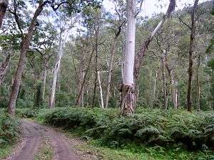 Eucalypus woodland in Wadbilliga National Park | |
| Ecology | |
| Realm | Australasian |
| Biome | temperate broadleaf and mixed forests |
| Borders | List
|
| Geography | |
| Area | 272,200 km2 (105,100 sq mi) |
| Country | Australia |
| States | Australian Capital Territory, New South Wales and Victoria |
| Conservation | |
| Conservation status | Critical/endangered |
Geography
The ecoregion covers most of the state of Victoria, and extends into southeastern New South Wales. It includes the coastal plain and the drier western slope of the Great Dividing Range. It surrounds the Australian Alps montane grasslands, which lie above 1200 in the highest portion of the Great Dividing Range.
It borders the Eastern Australian temperate forests to the northeast. The Southeast Australia temperate savanna lies to the north, the Murray-Darling woodlands and mallee lies to the northeast, and the Naracoorte woodlands lies to the east.
Melbourne, Australia's second-largest city, is the largest city in the ecoregion.
Protected areas
Protected areas include Croajingolong National Park, Snowy River National Park, and Wadbilliga National Park in the South East Corner, Grampians National Park in the Victorian Midlands, and Great Otway National Park in the coastal Otway Ranges southwest of Melbourne.
External links
- "Southeast Australia temperate forests". Terrestrial Ecoregions. World Wildlife Fund.
References
- "Southeast Australia temperate forests". Terrestrial Ecoregions. World Wildlife Fund.