South Fire
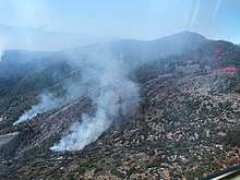
The South Fire was a wildfire that burned on the southeast side of Tomhead Mountain in Shasta-Trinity National Forest in Tehama County, California in the United States. The fire was started by a lightning strike, making it one of 26 reported fires in the area due to thunderstorm. As of October 17, the fire has burned 5,332 acres (2,158 ha) and is 75 percent contained. Select trails and roads in the fire area are closed.
| South Fire | |
|---|---|
 South Fire on September 8, 2019 | |
| Location | Tomhead Mountain, Tehama County, California, United States |
| Coordinates | 40.109°N 122.789°W |
| Statistics[1] | |
| Date(s) | September 5, 2019–October 11, 2019 |
| Burned area | 5,332 acres (2,158 ha) |
| Cause | Lightning |
| Map | |
 Location in California | |
Events
The South Fire was reported on September 5 at approximately 1:45 p.m. on the southeast side of Tomhead Mountain in Shasta-Trinity National Forest. It was started as a result of a lightning strike, along with 25 other reported fires in the area started due to a thunderstorm. As of September 6, the fire had burned an estimated 1,200 acres (486 ha) and 24-hours later, it had grown to 1,665 acres (674 ha).[1] Fire crews struggled to contain the fire due to the Red Bank Fire, which has blocked access to the South Fire. Fire authorities also moved resources to the Red Bank Fire, due to its size and proximity to populated areas. However, as of Sunday, September 8, fire crews were being sent to the South Fire, as crew gained control over the Red Bank Fire. No major structures have been threatened by the fire, which as of Sunday, was primarily burning on private land in a remote area.[2]
Impact
On September 17, portion of trails and roads are closed in the fire area in Shasta-Trinity National Forest.[3]
References
- "South Fire Information - InciWeb the Incident Information System". InciWeb. Shasta-Trinity National Forest. Retrieved 9 September 2019.
- Shulman, Alayna. "Separate lightning fire, South Fire, now burning 1,665 acres near Red Bank Fire". Record Searchlight. Retrieved 8 September 2019.
- "South Fire Incident Update 9-17-19 - InciWeb the Incident Information System". InciWeb. Shasta-Trinity National Forest. Retrieved 18 September 2019.
![]()
External links
