South Carolina Highway 41
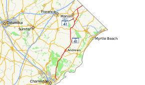
South Carolina Highway 41 (SC 41) is a 121.5-mile (195.5 km) state highway, connecting the Charleston region with eastern portions of the Pee Dee region in South Carolina. It serves as an alternative route to U.S. Route 52.
| ||||
|---|---|---|---|---|
 | ||||
| Route information | ||||
| Maintained by SCDOT | ||||
| Length | 121.5 mi[1] (195.5 km) | |||
| Existed | 1937–present | |||
| Major junctions | ||||
| South end | ||||
| North end | ||||
| Location | ||||
| Counties | Charleston, Berkeley, Williamsburg, Florence, Marion, Dillon | |||
| Highway system | ||||
| ||||

Route description
The route travels generally in a south-north direction, beginning in Mount Pleasant and ending at the North Carolina state line just north of Lake View, where it continues as North Carolina Highway 41 towards Lumberton. The route is mostly rural, though it serves as an important arterial in suburban Mount Pleasant and passes through several small towns on its route northwards. It also provides several key river and swamp crossings in the Pee Dee region.
History
Future
The Wando River Bridge, a through truss swing bridge built in 1939, is to be replaced by 2020-2021. The new bridge will be four-lane with median (which can be used as a fifth lane during emergencies), and will be a fixed span bridge, tall enough for tall ships to pass. At a planned cost of $42.3 million, construction began in mid-2015.[2][3][4]
Junction list
| County | Location | mi[1] | km | Destinations | Notes |
|---|---|---|---|---|---|
| Charleston | Mount Pleasant | 0.0 | 0.0 | ||
| Berkeley | | 5.0 | 8.0 | Wando River | |
| Huger | 17.2 | 27.7 | |||
| Jamestown | 32.3 | 52.0 | South end of US 17 Alt overlap | ||
| Williamsburg | | 38.2 | 61.5 | North end of US 17 Alt overlap | |
| | 43.7 | 70.3 | |||
| | 45.3 | 72.9 | South end of US 521 overlap | ||
| Andrews | 46.5 | 74.8 | North end of US 521 overlap | ||
| | 47.9 | 77.1 | |||
| | 49.7 | 80.0 | |||
| Rhems | 59.2 | 95.3 | South end of SC 51 overlap | ||
| | 61.6 | 99.1 | |||
| Rome Crossroads | 62.8 | 101.1 | |||
| Hemingway | 70.3 | 113.1 | |||
| Florence | Johnsonville | 74.9 | 120.5 | ||
| Kingsburg | 79.4 | 127.8 | West end of US 378 and north end of SC 51 overlap | ||
| Marion | Gresham | 83.0 | 133.6 | East end of US 378 overlap | |
| | 88.1 | 141.8 | |||
| Centenary | 91.6 | 147.4 | |||
| Ariel Crossroad | 96.3 | 155.0 | Interchange | ||
| Mullins | 106.0 | 170.6 | East end of SC 917 overlap | ||
| | 110.0 | 177.0 | West end of SC 917 overlap | ||
| Dillon | Fork | 112.3 | 180.7 | To Little Pee Dee State Park | |
| Lake View | 119.4 | 192.2 | |||
| | 121.5 | 195.5 | Continuation beyond North Carolina state line | ||
1.000 mi = 1.609 km; 1.000 km = 0.621 mi
| |||||
Special routes
Andrews business loop
| |
|---|---|
| Location | Andrews, South Carolina |
| Length | 4.6 mi[5] (7.4 km) |
| Existed | 1996–present |
Established between 1993-1996, it replaced mainline SC 41 through downtown Andrews. This is second business loop through Andrew, following exactly the same route from 1960-63 until 1970.[6]
| County | Location | mi[5] | km | Destinations | Notes |
|---|---|---|---|---|---|
| Williamsburg | | 0.0 | 0.0 | ||
| Georgetown | | 1.7 | 2.7 | ||
| Andrews | 3.1 | 5.0 | |||
| Williamsburg | | 4.6 | 7.4 | ||
| 1.000 mi = 1.609 km; 1.000 km = 0.621 mi | |||||
Marion alternate route
| |
|---|---|
| Location | Marion, South Carolina |
| Length | 23.0 mi[7] (37.0 km) |
| Existed | 1952–present |
Established in 1951 or 1952 as a new alternate route of SC 41 through Marion, though it did replace part of SC 175 south of Marion.[6]
| County | Location | mi[7] | km | Destinations | Notes |
|---|---|---|---|---|---|
| Marion | Centenary | 0.0 | 0.0 | ||
| | 9.0 | 14.5 | South end of US 501 Business overlap | ||
| | 9.4 | 15.1 | |||
| Marion | 11.5 | 18.5 | |||
| 12.4 | 20.0 | North end of US 501 Business overlap | |||
| | 15.8 | 25.4 | Interchange | ||
| Zion | Proposed interchange[8][9] | ||||
| Dillon | Smithboro | 21.2 | 34.1 | ||
| Fork | 23.0 | 37.0 | To Little Pee Dee State Park | ||
1.000 mi = 1.609 km; 1.000 km = 0.621 mi
| |||||
References
- Google (November 4, 2013). "South Carolina Highway 41" (Map). Google Maps. Google. Retrieved November 4, 2013.
- "Bridgehunter.com - Wando River Bridge". Retrieved November 4, 2013.
- "SC 41 - Bridge Replacement". Retrieved November 4, 2013.
- "SCDOT Active Projects - SC 41 Bridge over Wando River". Retrieved November 4, 2013.
- Google (September 3, 2012). "SC 41 Bus - Andrews" (Map). Google Maps. Google. Retrieved September 3, 2012.
- "Mapmikey's South Carolina Highways Page". Retrieved September 3, 2012.
- Google (September 3, 2012). "SC 41 Alt - Marion" (Map). Google Maps. Google. Retrieved September 3, 2012.
- Staff. "Project Status: Southern Project". I-73 Environmental Impact Study. South Carolina Department of Transportation. Retrieved November 3, 2013.
- I-73 Southern Map (PDF) (Map). South Carolina Department of Transportation. Marion inset. Retrieved November 3, 2013.
External links

- Mapmikey's South Carolina Highways Page: SC 41