South Carolina Highway 576
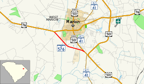
South Carolina Highway 576 (SC 576) is a primary state highway in the state of South Carolina. The three-mile (4.8 km) highway connects U.S. Route 76 (US 76) to US 501, south of Marion.
| ||||
|---|---|---|---|---|
 | ||||
| Route information | ||||
| Maintained by SCDOT | ||||
| Length | 3.09 mi[1] (4.97 km) | |||
| Existed | 1973–present | |||
| Major junctions | ||||
| West end | ||||
| East end | ||||
| Location | ||||
| Counties | Marion | |||
| Highway system | ||||
| ||||
Route description
SC 576 serves to keep the continuation of the four-lane divided highway that travelers get on in Florence to Myrtle Beach and vice versa.[2]
History
Established in 1973 as new primary routing, connecting US 76 and US 501 Business/SC 41 Alternate; it was built as a four-lane divided highway; it has remained unchanged since.[3][4]
Junction list
The entire route is in Marion County.
| Location | mi[1] | km | Destinations | Notes | |
|---|---|---|---|---|---|
| | 0.00 | 0.00 | |||
| | 3.09 | 4.97 | |||
| 1.000 mi = 1.609 km; 1.000 km = 0.621 mi | |||||
gollark: Some of them are infected with a version which says "osmarks was here", some run an older one.
gollark: Anyway, it's perfectly fine as long as no pages with `repl` in the name get visited.
gollark: Leaving HTML support on on the public demo instance was in fact a poor choice of mine.
gollark: With some fiddling, you can probably make replicators which piggyback on other ones.
gollark: http://osmarks.tk:8080/revisions/replstart.0.4.2They edit their own code into new pages. I plan to eventually make ones which hijack existing pages.
See also


References
- South Carolina Department of Transportation: Statewide Highways 2012. Specifics: . Files: .
- Google (June 30, 2013). "South Carolina Highway 576" (Map). Google Maps. Google. Retrieved June 30, 2013.
- General Highway Map, Marion County, South Carolina (PDF) (Map). Cartography by SCDOT. South Carolina Department of Transportation. 1968. Retrieved September 8, 2013.
- General Highway Map, Marion County, South Carolina (PDF) (Map). Cartography by SCDOT. South Carolina Department of Transportation. 1974. Retrieved September 8, 2013.
External links

- Mapmikey's South Carolina Highways Page: SC 570-599
This article is issued from Wikipedia. The text is licensed under Creative Commons - Attribution - Sharealike. Additional terms may apply for the media files.
