South Carolina Highway 146
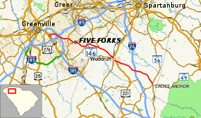
South Carolina Highway 146 is a 33 1⁄2-mile-long (53.9 km) South Carolina state highway running through Central Greenville County and south-western Spartanburg County.
| ||||
|---|---|---|---|---|
 | ||||
| Route information | ||||
| Maintained by SCDOT | ||||
| Length | 33.52 mi[1] (53.95 km) | |||
| Existed | 1942–present | |||
| Major junctions | ||||
| West end | ||||
| ||||
| East end | ||||
| Location | ||||
| Counties | Greenville, Spartanburg | |||
| Highway system | ||||
| ||||
Route description
SC 146's western terminus is at Laurens Road (U.S. Route 276 or US 276), near the intersection of Interstates 85 (I-85) and 385.[2] Its course then goes in a southeasterly direction where its eastern terminus is at its intersection with SC 56 near Cross Anchor.[2]
From its western terminus to its split from SC 417, SC 146 is known as Woodruff Road. From its split to the merger with SC 101, SC 146 is known as 3rd Street. Once SC 146/SC 101 merges with US 221 in Woodruff it is known as Main Street, then Laurens Road as it splits from SC 101. Its final name change happens when SC 146 splits from US 221 just outside Woodruff; its name changes to Cross Anchor Highway, and it keeps that name until it reaches its eastern terminus.
History
Major intersections
| County | Location | mi[1] | km | Destinations | Notes |
|---|---|---|---|---|---|
| Greenville | Greenville | 0.00 | 0.00 | ||
| 2.84– 3.10 | 4.57– 4.99 | I-85 exit 51A | |||
| | 3.49– 3.72 | 5.62– 5.99 | I-385 exit 35 | ||
| Five Forks | 5.59 | 9.00 | |||
| 7.36 | 11.84 | West end of SC 296 overlap | |||
| 8.06 | 12.97 | East end of SC 296 overlap | |||
| | 10.63 | 17.11 | West end of SC 417 overlap; roundabout | ||
| Spartanburg | | 11.99 | 19.30 | East end of SC 417 overlap; roundabout | |
| | 14.89 | 23.96 | West end of SC 101 overlap | ||
| | 19.43 | 31.27 | Eastern terminus of SC 418 | ||
| Woodruff | 19.59 | 31.53 | West end of US 221 overlap | ||
| 20.55 | 33.07 | East end of SC 101 overlap | |||
| 21.12 | 33.99 | East end of US 221 overlap | |||
| Hobbyville | 27.08– 27.19 | 43.58– 43.76 | I-26 exit 38 | ||
| Cross Anchor | 33.52 | 53.95 | |||
1.000 mi = 1.609 km; 1.000 km = 0.621 mi
| |||||
References
- "Statewide Highways (shapefile)" (zip). South Carolina Department of Transportation. September 29, 2017. Retrieved December 8, 2017.
- Google, Inc. Google Maps showing the whole course of SC 146. Data from Tele-Atlas. Retrieved on July 8, 2010.
External links
| Wikimedia Commons has media related to South Carolina Highway 146. |
