Solymar, Uruguay
Solymar is a coastal resort or residential neighbourhood of the Ciudad de la Costa in the Canelones Department of Uruguay. Its name is a contraction of the words "Sun and Sea".
Solymar | |
|---|---|
Resort of Ciudad de la Costa | |
 | |
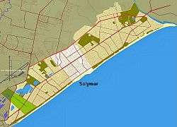 Location of Solymar in Ciudad de la Costa | |
| Coordinates: 34°49′35″S 55°57′54″W | |
| Country | |
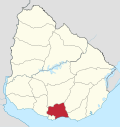
| Department | Canelones Department |
| Population (2011) | |
| • Total | 18,573 |
| Time zone | UTC -3 |
| Postal code | 15005 |
| Dial plan | +598 2 (+7 digits) |
Location
Solymar borders the coastline of the Río de la Plata to the south, El Bosque and Lagomar to the west, Lomas de Solymar to the east and its northern limit is formed by the highway Ruta Interbalnearia.
History
In 1994, when Ciudad de la Costa took on the status of a city, Solymar was incorporated in it. It borders the resorts Lagomar to the west, El Bosque to the southwest and Lomas de Solymar to the northeast.
Population
In 2011 Solymar had a population of 18,573.[1][2]
| Year | Population |
|---|---|
| 1963 | 542 |
| 1975 | 3,527 |
| 1985 | 6,607 |
| 1996 | 13,942 |
| 2004 | 15,908 |
| 2011 | 18,573 |
Source: Instituto Nacional de Estadística de Uruguay[3]
Places of worship
- Parish Church of Our Lady of the Foundation (Roman Catholic)
Street map
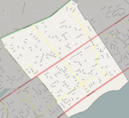
Street map of Solymar
gollark: I too love incomprehensible regexes?
gollark: A unified Perl syntax, yes.
gollark: Or, er, 7.0.
gollark: LyricLy has invented Perl 2.0™.
gollark: Lyric, produce/generate Macron?
References
- "Censos 2011 Cuadros Canelones" (XLS). INE. 2012. Retrieved 25 August 2012.
- "Censos 2011 Canelones (flash plugin needed)". INE. 2012. Retrieved 25 August 2012.
- "1963–1996 Statistics / S" (DOC). Instituto Nacional de Estadística de Uruguay. 2004. Retrieved 11 July 2011.
External links
Capital: Canelones | ||
| Towns and villages |
|  |
| Resorts of the Ciudad de la Costa | ||
| Sights |
| |
This article is issued from Wikipedia. The text is licensed under Creative Commons - Attribution - Sharealike. Additional terms may apply for the media files.