Estanque de Pando
Estanque de Pando is a northern suburb of Pando in the Canelones Department of southern Uruguay.
Estanque de Pando | |
|---|---|
Suburb of Pando | |
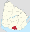
 Estanque de Pando Location in Uruguay | |
| Coordinates: 34°42′0″S 55°58′0″W | |
| Country | |
| Department | Canelones Department |
| Population (2011) | |
| • Total | 770 |
| Time zone | UTC -3 |
| Postal code | 91000 |
| Dial plan | +598 2 (+7 digits) |
Location
It is located on Route 75, about 2 kilometres (1.2 mi) north of Pando. It lies between the suburbs San Bernardo - Viejo Molino and Jardines de Pando.
Population
In 2011 Estanque de Pando had a population of 770.[1]
| Year | Population |
|---|---|
| 1985 | 296 |
| 1996 | 365 |
| 2004 | 641 |
| 2011 | 770 |
Source: Instituto Nacional de Estadística de Uruguay[2]
gollark: ...
gollark: ++magic pyc = bot.get_guild(346530916832903169).get_channel(348698124371361793)return f"#{c.name} \n*{c.topic}*\nPosition: {c.position}\nSlowmode: {c.slowmode_delay}\nLast message: {c.last_message_id}\nOverwrites: {[f'{o.type}({o.id}): {o.allow} ✅ {o.deny} ❎' for o in c._overwrites]}"
gollark: ++magic pyc = _bot.get_guild(346530916832903169).get_channel(348698124371361793)return f"#{c.name} \n*{c.topic}*\nPosition: {c.position}\nSlowmode: {c.slowmode_delay}\nLast message: {c.last_message_id}\nOverwrites: {[f'{o.type}({o.id}): {o.allow} ✅ {o.deny} ❎' for o in c._overwrites]}"
gollark: It said he was staff, lyricly.
gollark: ++magic sql SELECT * FROM marriages
References
- "Censos 2011 Canelones (flash plugin needed)". INE. 2012. Archived from the original on 7 September 2012. Retrieved 25 August 2012.
- "1963–1996 Statistics / E" (DOC). Instituto Nacional de Estadística de Uruguay. 2004. Retrieved 29 June 2011.
External links
Capital: Canelones | ||
| Towns and villages |
|  |
| Resorts of the Ciudad de la Costa | ||
| Sights |
| |
This article is issued from Wikipedia. The text is licensed under Creative Commons - Attribution - Sharealike. Additional terms may apply for the media files.