Solapur district
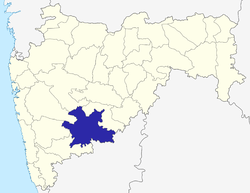
Solapur District is a district in Maharashtra state of India. The city of Solapur is the district headquarters. It is located on the south east edge of the state and lies entirely in the Bhima and Seena basins.[2] The entire district is drained by the Bhima River.[3]
Solapur district | |
|---|---|
District of Maharashtra | |
 Location of Solapur district in Maharashtra | |
| Coordinates (Solapur): 17°50′N 75°30′E | |
| Country | India |
| State | Maharashtra |
| Division | Pune Division[1] |
| Headquarters | Solapur |
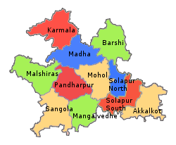
| Tehsils | 1. Akkalkot, 2. Barshi, 3. Karmala, 4. Madha, 5. Malshiras, 6. Mangalwedha, 7. Mohol, 8. Pandharpur, 9. Sangola, 10. Solapur North and 11. Solapur South |
| Government | |
| • Lok Sabha constituencies | 1. Solapur (SC), 2. Madha (shared with Satara district), 3. Osmanabad (shared with Osmanabad district) (Based on Election Commission website) |
| • Vidhan Sabha constituencies | 10 |
| Area | |
| • Total | 14,845 km2 (5,732 sq mi) |
| Population (2011) | |
| • Total | 4,317,756 |
| • Density | 290/km2 (750/sq mi) |
| • Urban | 31.83% |
| Demographics | |
| • Literacy | 71.2% |
| • Sex ratio | 935 |
| Time zone | UTC+05:30 (IST) |
| Major highways | National Highways 65,52,204,361,465,150E |
| Average annual precipitation | 545.4 mm |
| Website | http://solapur.gov.in/ |
Solapur district leads Maharashtra in production of Indian cigarettes known as beedi.[4]
Demographics
According to the 2011 census Solapur District has a population of 4,317,756, the 43rd largest for a district in India.
The district has a population density of 290 inhabitants per square kilometre (750/sq mi). Its population growth rate over the decade 2001-2011 was 12.1%. Solapur has a sex ratio of 932 females for every 1000 males, and a literacy rate of 77.72%.
At the time of the 2011 Census of India, 73.13% of the population in the district spoke Marathi, 9.28% Kannada, 7.80% Hindi, 5.04% Telugu and 3.94% Urdu as their first language.[5]
Marathi is the official language.[6]
| Year | Pop. | ±% p.a. |
|---|---|---|
| 1901 | 875,368 | — |
| 1911 | 946,761 | +0.79% |
| 1921 | 900,267 | −0.50% |
| 1931 | 1,058,959 | +1.64% |
| 1941 | 1,215,953 | +1.39% |
| 1951 | 1,490,446 | +2.06% |
| 1961 | 1,843,102 | +2.15% |
| 1971 | 2,233,369 | +1.94% |
| 1981 | 2,588,139 | +1.49% |
| 1991 | 3,231,057 | +2.24% |
| 2001 | 3,849,543 | +1.77% |
| 2011 | 4,317,756 | +1.15% |
| source:[7] | ||

Talukas
Solapur district is subdivided for administrative purposes into eleven talukas, which in turn comprise smaller divisions. The talukas are North Solapur, South Solapur, Akkalkot, Barshi, Mangalwedha, Pandharpur, Sangola, Malshiras, Mohol, Madha and Karmala.[8]
Places of interest
- Siddheshwar Temple and lake Siddheshwar Temple is a famous temple in Solapur .It is sacred to Hindus and members of the Lingayat faith. There is a lake within the temple complex.
- , Solapur
- Buikot killa It is a fort located near siddeshwar temple, Solapur.
- Pandharpur (Lord Vithoba Temple, 1, 2)
- Akkalkot (Swami Samarth Maharaj Temple)
- Ganagapur - Shri Dattatreya Temple
- Dahigaun - Jain Temple
- Nagnath Maharaj temple wadval ( taluka mohol )
- Karmala - Shri Kamala Bhavani Mandir( 96 Payarya Vihir( a small dip down lake of 96 stairs and having shape of Mahadev Pind) )
- Barshi - Bhagwant Mandir[9]
Celebrities
Born in Solapur District:
- M. F. Husain (Painter)
- Shashikala (Actress)
- फैयाज[10] ((Faiyyaz), Actress)
- Sarala Yeolekar (Actress)
- Lalchand Hirachand (Industrialist)
- Yusufkhan Mohamadkhan Pathan (Scholar)
- Jabbar Patel(Marathi Film Director)
- Akshar Kothari(Marathi and Hindi Film Actor)
- Atul Kulkarni (Marathi and Hindi Film Actor)
See also
References
- Sushant Kulkarni (3 July 2015). "Anti-Corruption Bureau: Pune Unit records highest number of bribery traps in state". The Indian Express. Pune. Retrieved 28 July 2015.
- Shri Mahadev Dada Tonpe, Mahavir Shah. "सोलापूर जिल्हा" [Solapur Jilha]. Solapur Pune Pravasi Sanghatna (in Marathi). Solapur. Retrieved 28 July 2015.
- "Solapur District Geographical Information". Archived from the original on 23 February 2007. Retrieved 11 December 2006.
- Meena Menon (21 June 2006). "A dream come true for beedi workers of Solapur". The Hindu. Mumbai. Retrieved 28 July 2015.
- 2011 Census of India, Population By Mother Tongue
- "Solapur census records". The Gezzeters department Solapur.
- Decadal Variation In Population Since 1901
- "Geographical information" (PDF). Solapur district. Retrieved 24 January 2018.
- https://solapur.gov.in/en/tourist-place/barshi/
- mr:फैयाज)
External links
| Wikimedia Commons has media related to Solapur district. |
- Official website of Solapur District
- Solapur District Gazetteer
- mSolapur - Mobile Governance Site
- A.G.Patil Polytechnic Institute, Solapur