Slate Islands (Ontario)
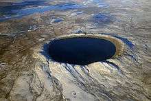
The Slate Islands archipelago is formed of two main islands, five minor islands and numerous islets located in northern Lake Superior, 10 kilometres (6 mi) south of the town of Terrace Bay. The islands were created by a meteorite impact which formed a crater about 32 km (20 mi) wide.[1] In 1985, the Ontario government established the Slate Islands as a natural environment provincial park. The islands are notable for having Ontario's largest herd of boreal woodland caribou.[2]
| Slate Islands Provincial Park | |
|---|---|
IUCN category II (national park) | |
 Landsat image (2019) | |
 | |
| Location | Ontario, Canada |
| Nearest city | Terrace Bay, Ontario |
| Coordinates | 48°39′0″N 87°00′0″W |
| Area | 65.70 km2 (25.37 sq mi) |
| Established | 1985 |
| Governing body | Ontario Parks |
The total surface area is about 36 square kilometres (14 sq mi). The nearby Leadman Group of islands one km (0.6 mi) east is often considered part of the Slate Islands.
Fauna
The islands are home to woodland caribou which have been studied extensively from 1974 to 2007 by Dr. A.T. (Tom) Bergerud. The caribou are a classic example of island biogeography in action; the islands are notable for species that are absent but present on the adjacent mainland (red squirrel, moose, white-tailed deer, and grouse). No ungulates were present on the islands until the caribou arrived in the early 1900s while predators have been present only sporadically. Caribou reached the highest population density in the world on the islands before the 1990s, with the herd estimated at 650 animals.[3] After a food shortage and die-off in 1990, the numbers were reduced to about 100.[3] In 2012 there were about 200 caribou on the Slate Islands.[4] Wolves reached the archipelago in the early 1990s preying heavily on the caribou but for reasons not entirely understood they disappeared a few years later. Wolves are again present on the island since winter 2015/16 (or earlier) as evidenced by aerial observation and scat.
Other mammals found on the islands include beaver, muskrat, snowshoe hare, short-tailed weasel, red-backed vole, and red fox.
The waters surrounding the Slate Islands have been protected from commercial fishing to preserve one of the last native stocks of lake trout in Lake Superior. The Islands have been a source of lake trout brood stock used at the Dorion Fish Hatchery, and fingerlings are planted back to Lake Superior to restore the fishery.
Flora

The cooling effect of Lake Superior makes the Slate Islands a particularly harsh habitat for its latitude. As a result, islands harbour arctic and alpine plant species such as alpine chickweed (at its most southerly occurrence),[5] Dryas drummondii (not found again for 1600 km (1000 mi) north),[5] and alpine bistort, an Inuit delicacy eaten with seal oil.[2] These arctic disjuncts are reminders of ice ages and associated tundra conditions in this area in the past.
Human history
Human sites have been found on the islands dating to about 1000CE.[6]
A lighthouse was built on Patterson Island, the largest island, in 1903 to help ships locate the harbour at the nearby town of Jackfish, Ontario. The island is named after William Patterson, a former lieutenant-governor of Saskatchewan. Later, a fishing station was built on McColl Island.
The original forests on the islands were modified by logging and forest fires. Up until the 1940s, the islands were used to stockpile boomed logs from the mainland Lake Superior north shore for export on lake freighters to pulp mills in the United States.
In 1985, the Slate Islands were protected as an Ontario Natural Environment Provincial Park. There are no facilities and the islands can only be accessed via boat or airplane. The islands remoteness is enforced by almost 9 km of open, wild, Lake Superior water and its distance from any large communities. It is frequented by naturalists, fishing parties, sailors exploring this Great Lake, and recently by an increasing number of sea kayaking parties.
Impact crater

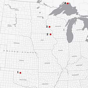
The Slate Islands mark the centre of a large meteorite impact crater. The original crater rim is estimated at about 32 km (20 mi) in diameter, but this and most of the crater has subsequently eroded away, leaving the islands which are interpreted as a central uplift. The age of the impact event is estimated to be about 450 million years (Ordovician).[7][8] Another source estimates the age at 800-500 million years (late Proterozoic to early Paleozoic).[9] It may be one of several Middle Ordovician meteors that fell roughly simultaneously 469 million years ago, part of a proposed Ordovician meteor event, including the Decorah crater in Iowa, the Ames crater in Oklahoma, and the Rock Elm crater in Wisconsin.[10]
Geology
The islands are not made of slate; the rock is mainly of metamorphosed volcanic rocks greater than 2.7 billion years old. Also present are sedimentary rocks of the Rove and Gunflint formations, approximately 1.85-2.10 billion years old. There is evidence that about 1.1 billion years ago, there was volcanic centre on Paterson Island, however almost all volcanic rocks have been removed by erosion.[11]
The youngest rocks are diatremes, referring to breccia-filled volcanic pipes that were formed by gaseous explosions. They occur as dikes or sills which criss-cross the all older rocks types.[11]
Also located in the islands are good examples of shatter cones, rare geological features formed in bedrock by the high velocity shock waves created by meteorite impacts. They have a distinctively conical shape with thin grooves (striae) that radiate from the top (apex) of the cone. The Slate Islands are home to a shatter cone measuring 9 m (30 ft), one of the largest examples in the world (pictured here).
Allogenic breccia is present, notably on the east and north sides of the islands.
References
- Sharpton, Dressler, (1996), p. 1177
- Chisholm & Gutsche 1998, p. 180.
- Godwin (1996), p. 3
- Creech, David (27 May 2012), Woodland Caribou of the Slate Islands, retrieved 22 January 2014
- Pye (1997), p. 83
- Chisholm & Gutsche 1998, p. 178.
- "Slate Islands". Earth Impact Database. Planetary and Space Science Centre University of New Brunswick Fredericton. Retrieved 15 September 2019.
- "ILSG Slate Islands trip". Retrieved 30 March 2008.
- Sharpton, Dressler, (1996), p. 1178
- Vastag, Brian (18 February 2013). "Crater found in Iowa points to asteroid break-up 470 million years ago". Washington Post. Retrieved 19 February 2013.
- Pye (1997), p. 84
Bibliography
- Chisholm, B.; Gutsche, A (1998), Superior: Under the Shadow of the Gods, Toronto: Lynx Images, ISBN 0-9698427-7-5
- Pye, E.G. (1997). Roadside Geology of Ontario: North Shore of Lake Superior, Ontario GEOservices Centre, ROCK ON Series 2. ISBN 0-7778-5850-9
- Sharpton, V.L. and Dressler, B.O. 'The Slate Islands Impact Structure: Structural Interpretation and Age Constraints', Lunar and Planetary Science. March 1996: vol. 27
- Godwin, L. (February 1996) "Woodland Caribou in Northwestern Ontario - Why they are different...", Northwestern Ontario Boreal Forest Management Technical Note TN-07


