Sinait
Sinait, officially the Municipality of Sinait (Ilocano: Ili ti Sinait; Filipino: Bayan ng Sinait), is a 3rd class municipality in the province of Ilocos Sur, Philippines. According to the 2015 census, it has a population of 25,640 people.[3]
Sinait | |
|---|---|
| Municipality of Sinait | |
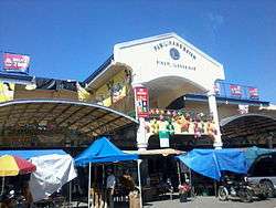
 Public Market | |
 Seal | |
| Nickname(s): Garlic Center of the North | |
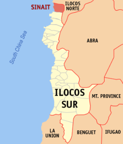
 Map of Ilocos Sur with Sinait highlighted | |

| |
.svg.png) Sinait Location within the Philippines | |
| Coordinates: 17°52′00″N 120°27′30″E | |
| Country | |
| Region | Ilocos Region (Region I) |
| Province | Ilocos Sur |
| District | 1st District |
| Barangays | 44 (see Barangays) |
| Government | |
| • Type | Sangguniang Bayan |
| • Mayor | Shee-an Guzman |
| • Vice Mayor | Clifford L. Ines |
| • Congressman | Deogracias Victor B. Savellano |
| • Electorate | 18,415 voters (2019) |
| Area | |
| • Total | 65.56 km2 (25.31 sq mi) |
| Population (2015 census)[3] | |
| • Total | 25,640 |
| • Density | 390/km2 (1,000/sq mi) |
| • Households | 5,872 |
| Economy | |
| • Income class | 3rd municipal income class |
| • Poverty incidence | 12.24% (2015)[4] |
| • Revenue (₱) | 289,589,957.93 (2016) |
| Time zone | UTC+8 (PST) |
| ZIP code | 2733 |
| PSGC | |
| IDD : area code | +63 (0)77 |
| Climate type | tropical monsoon climate |
| Native languages | Ilocano Tagalog |
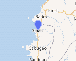
It is the northernmost municipality of the province and is 36 kilometres (22 mi) from the provincial capital, Vigan, 46 kilometres (29 mi) from Laoag, and 441 kilometres (274 mi) from Manila.
Because of its main commodity, garlic, Sinait is also known as the Garlic Center of the North.
History
Before Magellan discovered the Philippines in 1521, the locality was only a small village of little over a hundred natives who were called "Tirongs." By nature, these primitive inhabitants were sea-faring warlike. In their fast and picturesque sailboats, they traveled to adjoining and distant places, most particularly to settlements and villages along the Ilocos Coast in Ilocos Norte, Ilocos Sur, La Union, Pangasinan and even Zambales. In those adventures, the “Tirongs “ always challenged the people encountered to tribal wars and fought small battles against them. Often, those sturdy and brave natives came out victorious. Even in their daily chores, those people showed their ferocious characteristics. When the renowned Iberians came, Salcedo was sent to explore and colonized the Ilocos territory during the early years of the Spanish regime, he found the “Tirongs” of Sinait in apogee of the social state. Small battles were daily occurrence so that in the year 1535, when the locality was organized and established as a “Pueblo” Salcedo named the new community as “SIN-NAIT”, a word in the local tongue which means “CONTEST”. As a pueblo, SINAIT embraced and included in its territorial limit such as distant places as RANCHERA DE PAUR”, now the Municipality of Nueva Era in Ilocos Norte and Southern barrios of Badoc of the same Province. The vast territory, however, was reduced to present 78 square kilometers. In the year 1575, the natives fully realized the hardships of pronouncing the term “SIN-NAIT” and to go away with the trouble, Salcedo declared that one of the letter “N” be dropped. Since then, this Municipality has been called “SINAIT”. Nevertheless, it was only in 1913 when the same was “deeded” by the government upon the initiative of the late Don Calixto Cabacungan so that the Municipality Council enacted a resolution to that effect, that SINAIT was adopted as official name of the community to which said resolution was duly approved by the Provincial board of Ilocos Sur and by the Defunct Philippine Legislature.
The Santo Cristo Milagroso

Sinait houses the Sanctuary of the Miraculous Statue of the Black Nazarene (El Santo Cristo Milagroso), fondly called by its residents as "Apo Lakay," and a treasure of Ilocandia. History traces the life-sized statue to Nagasaki, Japan. It was probably sent floating in the sea by missionaries operating in secret in Japan (for fear of persecution during the Tokugawa Bakufu). The box was found by local fishermen in the shores of Barangay Dadalaquiten Norte, on the boundary between Sinait and nearby Paguetpet (La Virgen Milagrosa), Badoc, in the year 1620, and fishermen from both towns carried it ashore. They found two statues inside the box—a statue of the Black Nazarene, and a statue of the Blessed Virgin Mary. According to legend, The fishermen from Sinait mysteriously were unable to move the statue of the Blessed Virgin Mary, but had no problems moving the Statue of the Black Nazarene. The fishermen from Badoc, however, were able to move the Statue of the Blessed Virgin Mary (later called the La Virgen Milagrosa) with ease, as they were unable to carry the image of the Black Nazarene. They took the statues to their respective towns, hence becoming their patron saints. In 1656, with a spreading devotion to the Santo Cristo Milagroso due to its miraculous powers, the Black Crucifix was taken to the capital town of Vigan, since an epidemic was raging there and through the devotion of the faithful, many got cured. Because of this, it is considered as an intercessor of all kinds of affliction and sickness. In 1660, because of the growing veneration to the image, the faithful begun the construction of a permanent edifice to house it. It took the people of Sinait eight years to construct the church with funds provides by the Spanish Audiencia. Today the landing site of Apo Lakay still exists in Barangay Dadalaquiten Norte, and is a place of pilgrimage for devotees.
Barangays
Sinait is politically subdivided into 44 barangays. [2]
- Aguing
- Ballaigui (Poblacion)
- Baliw
- Baracbac
- Barikir
- Battog
- Binacud
- Cabangtalan
- Cabarambanan
- Cabulalaan
- Cadanglaan
- Calingayan
- Curtin
- Dadalaquiten Norte
- Dadalaquiten Sur
- Duyayyat
- Jordan
- Calanutian
- Katipunan
- Macabiag (Poblacion)
- Magsaysay
- Marnay
- Masadag
- Nagcullooban
- Nagbalioartian
- Nagongburan
- Namnama (Poblacion)
- Pacis
- Paratong
- Dean Leopoldo Yabes (Pug-os)
- Purag
- Quibit-quibit
- Quimmallogong
- Rang-ay (Poblacion)
- Ricudo
- Sabangan (Marcos)
- Sallacapo
- Santa Cruz
- Sapriana
- Tapao
- Teppeng
- Tubigay
- Ubbog
- Zapat
Climate
| Climate data for Sinait, Ilocos Sur | |||||||||||||
|---|---|---|---|---|---|---|---|---|---|---|---|---|---|
| Month | Jan | Feb | Mar | Apr | May | Jun | Jul | Aug | Sep | Oct | Nov | Dec | Year |
| Average high °C (°F) | 30 (86) |
31 (88) |
33 (91) |
34 (93) |
33 (91) |
31 (88) |
30 (86) |
30 (86) |
30 (86) |
31 (88) |
30 (86) |
29 (84) |
31 (88) |
| Average low °C (°F) | 19 (66) |
19 (66) |
21 (70) |
23 (73) |
24 (75) |
25 (77) |
24 (75) |
24 (75) |
24 (75) |
22 (72) |
21 (70) |
19 (66) |
22 (72) |
| Average precipitation mm (inches) | 9 (0.4) |
11 (0.4) |
13 (0.5) |
23 (0.9) |
92 (3.6) |
122 (4.8) |
153 (6.0) |
137 (5.4) |
139 (5.5) |
141 (5.6) |
42 (1.7) |
14 (0.6) |
896 (35.4) |
| Average rainy days | 4.6 | 4.0 | 6.2 | 9.1 | 19.5 | 23.2 | 24.0 | 22.5 | 21.5 | 15.2 | 10.5 | 6.0 | 166.3 |
| Source: Meteoblue [5] | |||||||||||||
Demographics
| Year | Pop. | ±% p.a. |
|---|---|---|
| 1903 | 9,157 | — |
| 1918 | 12,335 | +2.01% |
| 1939 | 11,722 | −0.24% |
| 1948 | 12,015 | +0.27% |
| 1960 | 15,170 | +1.96% |
| 1970 | 16,429 | +0.80% |
| 1975 | 17,952 | +1.79% |
| 1980 | 19,050 | +1.19% |
| 1990 | 21,779 | +1.35% |
| 1995 | 22,608 | +0.70% |
| 2000 | 24,070 | +1.35% |
| 2007 | 24,896 | +0.47% |
| 2010 | 25,427 | +0.77% |
| 2015 | 25,640 | +0.16% |
| Source: Philippine Statistics Authority[3][6][7][8] | ||
In the 2015 census, the population of Sinait was 25,640 people,[3] with a density of 390 inhabitants per square kilometre or 1,000 inhabitants per square mile.
Points of interest
- Sinait Public Market - On certain days garlic from the municipality and even the neighboring municipalities of Badoc and Pinili in neighboring Ilocos Norte are traded here.
- Barangay Pug-os/Dean Leopoldo Yabes - Barangay Pug-os was renamed as Barangay Dean Leopoldo Yabes, in honor of the Ilocano writer and dean from the University of the Philippines who once lived in Sinait.
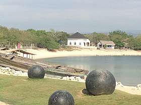
- Cabangtalan (Imelda's Cove) - Features white sand beaches. It is located on the way to Barangay Dadalaquiten Norte and Paguetpet (Badoc).
- San Nicolas de Tolentino Church/Sanctuary of the Miraculous Statue of the Black Nazarene (El Santo Cristo Milagroso) - Houses the "Miraculous Statue of El Santo Cristo Milagroso", or "Apo Lakay."
- Barangay Dadalaquiten Norte - The landing place of the Miraculous Statue of the Black Nazarene in 1620, close to the landing place of the La Virgen Milagrosa in neighboring Paguetpet, Badoc, Ilocos Norte.
- Libunao Protected Landscape - A protected watershed area in Barangay Nagcullooban.
- Sinait National High School - One of the largest secondary schools in Ilocos Sur.
- Calanutian - Homeplace of Inez Cannoyan the wife of Lam-Ang in the fictional Ilocano Story Biag ni Lam-Ang
- Dadalaquiten Floating Cottages - A summer destination located at Dadalaquiten Norte
- Cabulalaan Hills - A hiking destination.
References
- "Municipality". Quezon City, Philippines: Department of the Interior and Local Government. Retrieved 31 May 2013.
- "Province: Ilocos Sur". PSGC Interactive. Quezon City, Philippines: Philippine Statistics Authority. Retrieved 12 November 2016.
- Census of Population (2015). "Region I (Ilocos Region)". Total Population by Province, City, Municipality and Barangay. PSA. Retrieved 20 June 2016.
- "PSA releases the 2015 Municipal and City Level Poverty Estimates". Quezon City, Philippines. Retrieved 1 January 2020.
- "Sinait: Average Temperatures and Rainfall". Meteoblue. Retrieved 14 May 2020.
- Census of Population and Housing (2010). "Region I (Ilocos Region)". Total Population by Province, City, Municipality and Barangay. NSO. Retrieved 29 June 2016.
- Censuses of Population (1903–2007). "Region I (Ilocos Region)". Table 1. Population Enumerated in Various Censuses by Province/Highly Urbanized City: 1903 to 2007. NSO.
- "Province of Ilocos Sur". Municipality Population Data. Local Water Utilities Administration Research Division. Retrieved 17 December 2016.
External links
| Wikimedia Commons has media related to Sinait, Ilocos Sur. |