Sieversdorf-Hohenofen
Sieversdorf-Hohenofen is a municipality in the Ostprignitz-Ruppin district, in Brandenburg, Germany.
Sieversdorf-Hohenofen | |
|---|---|
 Coat of arms | |
Location of Sieversdorf-Hohenofen within Ostprignitz-Ruppin district 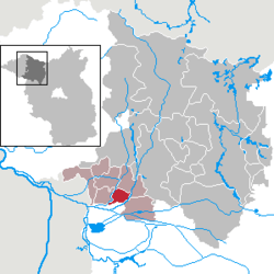 | |
 Sieversdorf-Hohenofen  Sieversdorf-Hohenofen | |
| Coordinates: 52°49′30″N 12°24′17″E | |
| Country | Germany |
| State | Brandenburg |
| District | Ostprignitz-Ruppin |
| Municipal assoc. | Neustadt (Dosse) |
| Subdivisions | 2 Ortsteile |
| Government | |
| • Mayor | Hermann Haacke |
| Area | |
| • Total | 19.83 km2 (7.66 sq mi) |
| Elevation | 28 m (92 ft) |
| Population (2018-12-31)[1] | |
| • Total | 684 |
| • Density | 34/km2 (89/sq mi) |
| Time zone | CET/CEST (UTC+1/+2) |
| Postal codes | 16845 |
| Dialling codes | 033970 |
| Vehicle registration | OPR |
| Website | www.sieversdorf-hohenofen.de |
Demography
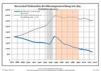
Development of population since 1875 within the current boundaries (Blue line: Population; Dotted line: Comparison to population development of Brandenburg state; Grey background: Time of Nazi rule; Red background: Time of communist rule)
|
|
gollark: Not really. It'll probably shatter or something.
gollark: ... 5V, apparently, so maybe not, huh.
gollark: Apparently it's a voltage regulator. You probably need that.
gollark: Not you, the person with the weird Unicodey name.
gollark: Please just explain your problem with sensible grammar and capitalization and whatnot.
References
- "Bevölkerung im Land Brandenburg nach amtsfreien Gemeinden, Ämtern und Gemeinden 31. Dezember 2018". Amt für Statistik Berlin-Brandenburg (in German). July 2019.
- Detailed data sources are to be found in the Wikimedia Commons.Population Projection Brandenburg at Wikimedia Commons
Towns and municipalities in Ostprignitz-Ruppin | ||
|---|---|---|
Coat of Arms of Ostprignitz-Ruppin district | ||
| Authority control |
|
|---|
This article is issued from Wikipedia. The text is licensed under Creative Commons - Attribution - Sharealike. Additional terms may apply for the media files.