Herzberg, Ostprignitz-Ruppin
Herzberg is a municipality in the Ostprignitz-Ruppin district, in Brandenburg, Germany.

Alcove house
Herzberg | |
|---|---|
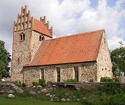 Church | |
Location of Herzberg within Ostprignitz-Ruppin district _in_OPR.png) | |
 Herzberg  Herzberg | |
| Coordinates: 52°53′59″N 12°58′59″E | |
| Country | Germany |
| State | Brandenburg |
| District | Ostprignitz-Ruppin |
| Municipal assoc. | Lindow (Mark) |
| Government | |
| • Mayor | Michaela Wolff |
| Area | |
| • Total | 18.57 km2 (7.17 sq mi) |
| Elevation | 46 m (151 ft) |
| Population (2018-12-31)[1] | |
| • Total | 627 |
| • Density | 34/km2 (87/sq mi) |
| Time zone | CET/CEST (UTC+1/+2) |
| Postal codes | 16835 |
| Dialling codes | 033926 |
| Vehicle registration | OPR |
Demography
.pdf.jpg)
Development of population since 1875 within the current boundaries (Blue line: Population; Dotted line: Comparison to population development of Brandenburg state; Grey background: Time of Nazi rule; Red background: Time of communist rule)
|
|
gollark: @AnarchoKarl#0976
gollark: https://cdn.discordapp.com/attachments/461970193728667648/878681904277229578/video0.mov
gollark: Done.
gollark: I see. I'll inform our analysts.
gollark: Was it informative?
References
- "Bevölkerung im Land Brandenburg nach amtsfreien Gemeinden, Ämtern und Gemeinden 31. Dezember 2018". Amt für Statistik Berlin-Brandenburg (in German). July 2019.
- Detailed data sources are to be found in the Wikimedia Commons.Population Projection Brandenburg at Wikimedia Commons
Towns and municipalities in Ostprignitz-Ruppin | ||
|---|---|---|
Coat of Arms of Ostprignitz-Ruppin district | ||
| Authority control |
|---|
This article is issued from Wikipedia. The text is licensed under Creative Commons - Attribution - Sharealike. Additional terms may apply for the media files.