Selje
Selje is a former municipality in the county of Sogn og Fjordane, Norway. It was located in the traditional district of Nordfjord. The village of Selje was the administrative center of the municipality.
Selje kommune | |
|---|---|
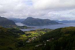 View of the island of Barmen in Selje | |
 Coat of arms 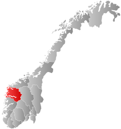 Sogn og Fjordane within Norway | |
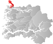 Selje within Sogn og Fjordane | |
| Coordinates: 62°08′14″N 05°13′23″E | |
| Country | Norway |
| County | Sogn og Fjordane |
| District | Nordfjord |
| Established | 1 Jan 1838 |
| Disestablished | 1 Jan 2020 |
| Administrative centre | Selje |
| Government | |
| • Mayor (2015-2019) | Stein Robert Osdal (KrF) |
| Area | |
| • Total | 226.12 km2 (87.31 sq mi) |
| • Land | 219.88 km2 (84.90 sq mi) |
| • Water | 6.24 km2 (2.41 sq mi) 2.8% |
| Area rank | 317 in Norway |
| *Area at municipal dissolution. | |
| Population (2018) | |
| • Total | 2,757 |
| • Rank | 279 in Norway |
| • Density | 12.5/km2 (32/sq mi) |
| • Change (10 years) | -4% |
| Demonym(s) | Seljeværing[1] |
| Time zone | UTC+01:00 (CET) |
| • Summer (DST) | UTC+02:00 (CEST) |
| ISO 3166 code | NO-1441 |
| Official language form | Nynorsk[2] |
| Created as | Formannskapsdistrikt in 1838 |
| Succeeded by | Stad in 2020 |
| Website | selje |
Selje was located at the northwesternmost part of Sogn og Fjordane county. Most of the municipality was located on and around the Stadlandet peninsula as well as some small surrounding islands such as Selja and Barmøya. The Stad Ship Tunnel is a proposed tunnel/canal through a small isthmus connecting the Moldefjorden to the Vanylvsfjorden, and it would prevent the need for boats to travel around the Stad peninsula—a particularly dangerous sea route.
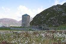
Selje was one of the first three Episcopal sees in Norway (Oslo, Nidaros, and Selje). After the diocese was moved to Bergen, monks took over the church in Selje, which was later destroyed by pirates in 1536. The municipality of Selje is also home to the Selje Abbey, a former Benedictine monastery located on the island of Selja. There are ruins of the abbey and church can still be seen on the island.[3]
At the time of its dissolution in 2020, the 226-square-kilometre (87 sq mi) municipality is the 317th largest by area out of the 422 municipalities in Norway. Selje is the 279th most populous municipality in Norway with a population of 2,757. The municipality's population density is 12.5 inhabitants per square kilometre (32/sq mi) and its population has decreased by 4% over the last decade.[4][5]
General information
Selje was established as a municipality on 1 January 1838 (see formannskapsdistrikt law). The original municipality was identical to the historic Selje prestegjeld with the sub-parishes (sokn) of Hove and Vågsøy. The municipality originally included all of the Stadlandet peninsula, the island of Vågsøy and the mainland area north of the mouth of the Nordfjorden.
On 1 January 1910, the southwestern district of Vågsøy was separated from Selje to form two new municipalities: Nord-Vågsøy and Sør-Vågsøy. The sub-parish of Hove was renamed Selje at the same time. After the separation, Selje had a population of 3,367 residents.[6]
During the 1960s, there were many municipal mergers across Norway due to the work of the Schei Committee. On 1 January 1964, the municipalities of Nord-Vågsøy and Sør-Vågsøy as well as a small part of southern Selje municipality were merged to form the new Vågsøy Municipality. The parts of Selje involved were the island of Silda, the Hagevik-Osmundsvåg area, and the farms of Sørpollen and Straumen.[7] There were 344 residents in those areas that were moved out of Selje.[6]
On 1 January 2020, Selje was dissolved as a municipality and it was merged with the neighboring municipality of Eid and the Bryggja-Totland area of Vågsøy and they formed the new Stad Municipality.[8][9]
Name
The municipality (originally the parish) is named after the small island of Selja, since the first Selje Church was built there. The meaning of the name is unknown. Prior to 1889, the name was written Selø or Selløe.[10]
Coat of arms
The coat of arms was granted on 5 April 1991. They are blue and silver, showing the upper half of a woman with raised arms and crown. The woman is a depiction of Saint Sunniva, the royal Irish missionary who died as a martyr on the island of Selja while trying to convert he locals to Christianity. Later, the Selje Abbey was built on the spot where she died. She was later named the patron saint of the Norwegian Diocese of Bjørgvin and all of Western Norway.[11][12]
Churches
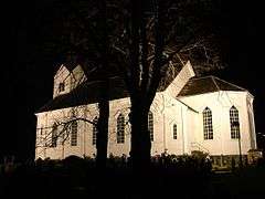
The Church of Norway has three parishes (sokn) within the municipality of Selje. It is part of the Nordfjord prosti (deanery) in the Diocese of Bjørgvin.[13][14]
| Parish (sokn) | Church name | Location of the church | Year built |
|---|---|---|---|
| Ervik | Ervik Church | Ervik | 1970 |
| Leikanger | Leikanger Church | Leikanger | 1866 |
| Selje | Selje Church | Selje | 1866 |
Also, the ruins of the Selje Abbey (built in 1100) are located on the island of Selja.
Government
All municipalities in Norway, including Selje, are responsible for primary education (through 10th grade), outpatient health services, senior citizen services, unemployment and other social services, zoning, economic development, and municipal roads. The municipality is governed by a municipal council of elected representatives, which in turn elect a mayor.[15] The municipality falls under the Sogn og Fjordane District Court and the Gulating Court of Appeal.
Municipal council
The municipal council (Kommunestyre) of Selje was made up of 17 representatives that were elected to four year terms. The party breakdown of the final municipal council was as follows:
| Party Name (in Nynorsk) | Number of representatives | |
|---|---|---|
| Labour Party (Arbeidarpartiet) | 1 | |
| Progress Party (Framstegspartiet) | 4 | |
| Conservative Party (Høgre) | 2 | |
| Christian Democratic Party (Kristeleg Folkeparti) | 2 | |
| Centre Party (Senterpartiet) | 3 | |
| Cross-party list (Tverrpolitisk liste) | 5 | |
| Total number of members: | 17 | |
| Party Name (in Nynorsk) | Number of representatives | |
|---|---|---|
| Labour Party (Arbeidarpartiet) | 1 | |
| Progress Party (Framstegspartiet) | 4 | |
| Conservative Party (Høgre) | 3 | |
| Christian Democratic Party (Kristeleg Folkeparti) | 3 | |
| Centre Party (Senterpartiet) | 1 | |
| Cross-party list (Tverrpolitisk liste) | 5 | |
| Total number of members: | 17 | |
| Party Name (in Nynorsk) | Number of representatives | |
|---|---|---|
| Labour Party (Arbeidarpartiet) | 4 | |
| Progress Party (Framstegspartiet) | 4 | |
| Conservative Party (Høgre) | 3 | |
| Christian Democratic Party (Kristeleg Folkeparti) | 3 | |
| Centre Party (Senterpartiet) | 2 | |
| People's common list (Folkeleg fellesliste) | 1 | |
| Total number of members: | 17 | |
| Party Name (in Nynorsk) | Number of representatives | |
|---|---|---|
| Labour Party (Arbeidarpartiet) | 4 | |
| Progress Party (Framstegspartiet) | 3 | |
| Conservative Party (Høgre) | 2 | |
| Christian Democratic Party (Kristeleg Folkeparti) | 4 | |
| Centre Party (Senterpartiet) | 2 | |
| People's common list (Folkeleg fellesliste) | 2 | |
| Total number of members: | 17 | |
| Party Name (in Nynorsk) | Number of representatives | |
|---|---|---|
| Labour Party (Arbeidarpartiet) | 4 | |
| Progress Party (Framstegspartiet) | 4 | |
| Conservative Party (Høgre) | 6 | |
| Christian Democratic Party (Kristeleg Folkeparti) | 5 | |
| Centre Party (Senterpartiet) | 1 | |
| Cross-party common list (Tverrpolitisk samlingsliste) | 3 | |
| People's common list (Folkeleg fellesliste) | 2 | |
| Total number of members: | 25 | |
| Party Name (in Nynorsk) | Number of representatives | |
|---|---|---|
| Labour Party (Arbeidarpartiet) | 5 | |
| Conservative Party (Høgre) | 8 | |
| Christian Democratic Party (Kristeleg Folkeparti) | 3 | |
| Centre Party (Senterpartiet) | 3 | |
| Socialist Left Party (Sosialistisk Venstreparti) | 1 | |
| Liberal Party (Venstre) | 1 | |
| Cross-party common list (Tverrpolitisk samlingsliste) | 4 | |
| Total number of members: | 25 | |
| Party Name (in Nynorsk) | Number of representatives | |
|---|---|---|
| Labour Party (Arbeidarpartiet) | 6 | |
| Conservative Party (Høgre) | 6 | |
| Christian Democratic Party (Kristeleg Folkeparti) | 4 | |
| Centre Party (Senterpartiet) | 5 | |
| Liberal Party (Venstre) | 1 | |
| Non-political common list (Upolitisk samlingsliste) | 3 | |
| Total number of members: | 25 | |
| Party Name (in Nynorsk) | Number of representatives | |
|---|---|---|
| Labour Party (Arbeidarpartiet) | 6 | |
| Conservative Party (Høgre) | 7 | |
| Christian Democratic Party (Kristeleg Folkeparti) | 5 | |
| Centre Party (Senterpartiet) | 3 | |
| Liberal Party (Venstre) | 4 | |
| Total number of members: | 25 | |
| Party Name (in Nynorsk) | Number of representatives | |
|---|---|---|
| Labour Party (Arbeidarpartiet) | 7 | |
| Conservative Party (Høgre) | 7 | |
| Christian Democratic Party (Kristeleg Folkeparti) | 6 | |
| Centre Party (Senterpartiet) | 4 | |
| Liberal Party (Venstre) | 1 | |
| Total number of members: | 25 | |
| Party Name (in Nynorsk) | Number of representatives | |
|---|---|---|
| Labour Party (Arbeidarpartiet) | 5 | |
| Conservative Party (Høgre) | 6 | |
| Christian Democratic Party (Kristeleg Folkeparti) | 6 | |
| Centre Party (Senterpartiet) | 5 | |
| Liberal Party (Venstre) | 3 | |
| Total number of members: | 25 | |
| Party Name (in Nynorsk) | Number of representatives | |
|---|---|---|
| Labour Party (Arbeidarpartiet) | 2 | |
| Conservative Party (Høgre) | 8 | |
| Christian Democratic Party (Kristeleg Folkeparti) | 6 | |
| Liberal Party (Venstre) | 4 | |
| Non-party Election List for the Moldestad area (Upolitisk Valliste for Moldestad Krins) | 1 | |
| Election List for the Stokkevåg area (Valliste for Stokkevåg Krins) | 1 | |
| Non-party Election List for outer, middle, and southern Selje (Upolitisk Valliste for Ytre, Midtre og Søre Selje) | 3 | |
| Total number of members: | 25 | |
| Party Name (in Nynorsk) | Number of representatives | |
|---|---|---|
| Labour Party (Arbeidarpartiet) | 2 | |
| Conservative Party (Høgre) | 5 | |
| Local List(s) (Lokale lister) | 18 | |
| Total number of members: | 25 | |
| Party Name (in Nynorsk) | Number of representatives | |
|---|---|---|
| Local List(s) (Lokale lister) | 25 | |
| Total number of members: | 25 | |
| Party Name (in Nynorsk) | Number of representatives | |
|---|---|---|
| Local List(s) (Lokale lister) | 25 | |
| Total number of members: | 25 | |
| Party Name (in Nynorsk) | Number of representatives | |
|---|---|---|
| Conservative Party (Høgre) | 3 | |
| Local List(s) (Lokale lister) | 22 | |
| Total number of members: | 25 | |
| Party Name (in Nynorsk) | Number of representatives | |
|---|---|---|
| Labour Party (Arbeidarpartiet) | 3 | |
| Conservative Party (Høgre) | 5 | |
| Local List(s) (Lokale lister) | 17 | |
| Total number of members: | 25 | |
| Party Name (in Nynorsk) | Number of representatives | |
|---|---|---|
| Local List(s) (Lokale lister) | 24 | |
| Total number of members: | 24 | |
| Party Name (in Nynorsk) | Number of representatives | |
|---|---|---|
| Local List(s) (Lokale lister) | 24 | |
| Total number of members: | 24 | |
| Party Name (in Nynorsk) | Number of representatives | |
|---|---|---|
| Local List(s) (Lokale lister) | 24 | |
| Total number of members: | 24 | |
| Party Name (in Nynorsk) | Number of representatives | |
|---|---|---|
| Local List(s) (Lokale lister) | 24 | |
| Total number of members: | 24 | |
Mayor
The mayor (ordførar) of a municipality in Norway is a representative of the majority party of the municipal council who is elected to lead the council. Stein Robert Osdal of the Christian People's Party was elected mayor for the 2015–2019 term.
Many previous mayors have later entered national or regional politics: Ottar Nygård, Julius Fure, Magne Aarøen, Åge Starheim, and Sverre J. Hoddevik.
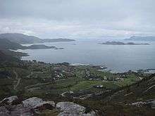
Geography

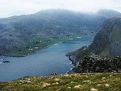
Selje is located in the northwesternmost part of Sogn og Fjordane county, in the Nordfjord region. It includes the Stad peninsula and the islands of Barmøya, Venøya, and Selja. Selje is surrounded by water on three sides. The Sildagapet bay on the west, the North Sea to the north, and the Vanylvsfjorden to the northeast. Selje municipality is bordered to the south and west by Vågsøy Municipality and to the east by Vanylven and Sande municipalities (in Møre og Romsdal county).
Economy
The main industries in the municipality of Selje have been fishing and farming. These industries are still present in Selje, with the addition of new industries such as fish breeding, boat building, ready-made clothing manufacturing, and service industries.[3] The Skorge Hydroelectric Power Station is located in the municipality.
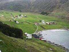
Villages and neighborhoods
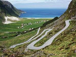
Villages and neighborhoods in the municipality include Barmen, Ervik, Flatraket, Hoddevik, Hoddevika, Håvik, and Leikanger.
Attractions
Selja
On the island of Selja, a 15-minute boat trip from the village of Selje, lie the ruins of the Selje Abbey, its tower still intact. The abbey was built by Benedictine monks early in the 12th century in honour of St. Sunniva. The legend of St. Sunniva who was martyred here lives on. Norway has two male saints (St. Olav and St. Hallvard) and one female one, St. Sunniva, the guardian saint of Western Norway. According to legend, Sunniva, daughter of an Irish king, fled when her country was conquered by heathens and the new king wanted to marry her. She came ashore on the island of Selja. The St. Sunniva cave where Sunniva is said to have died is a large cavern containing remains of walls and traces of the first church dedicated to the Archangel Michael.
The island of Selja is also home to the following sites:
- The site of the first Selje Church which was later moved to the mainland. The ruins of St. Sunniva's Church on the site where Olav Trygvasson built one of the first churches in Norway.
- The ruins of St. Alban's Church, the monastery church dedicated to the English Saint Alban. The monastery ruins are still used for church ceremonies such as masses and weddings.
- Several Viking graves and the remains of an Iron Age long house have also been found on the south side of the island.[3]
Vestkapp
The part of Norway's mainland that is farthest west is in Selje. The West Cape (Vestkapp) is 496 metres (1,627 ft) above sea level at the northwestern end of the Stad peninsula. It is a precipitous rocky plateau, almost flat on top, that drops steeply down to the sea. In good weather, there is a panoramic view in all directions. It is immediately north of the village of Ervik.[3]
Ervik
Ervik is located by the ocean near the West Cape at the end of the Stad peninsula. The Ervik Church is located here in memory of those who died when the coastal express ship Sanct Svithun was wrecked here after being mistakenly bombed in 1943 by Canadian planes. Ervik has a fine sandy beach which is popular for surfing, and a river rich in trout and salmon.[3]
References
- "Navn på steder og personer: Innbyggjarnamn" (in Norwegian). Språkrådet.
- "Forskrift om målvedtak i kommunar og fylkeskommunar" (in Norwegian). Lovdata.no.
- "Selje Municipality in Norway". GoNorway.com. Retrieved 20 July 2008.
- Statistisk sentralbyrå (2018). "Table: 06913: Population 1 January and population changes during the calendar year (M)" (in Norwegian). Retrieved 2019-10-05.
- Statistisk sentralbyrå. "09280: Area of land and fresh water (km²) (M)" (in Norwegian). Retrieved 2019-10-05.
- Jukvam, Dag (1999). "Historisk oversikt over endringer i kommune- og fylkesinndelingen" (PDF) (in Norwegian). Statistisk sentralbyrå.
- "The municipality of Selje". 19 March 2007. Archived from the original on 21 July 2011. Retrieved 20 July 2008.
- "Stad 2020: Eid og Selje i ny kommune" (in Norwegian). Retrieved 2017-10-22.
- "Bryggja inn i Stad kommune" (in Norwegian). Nye Stad kommune. Retrieved 2019-10-05.
- Rygh, Oluf (1919). Norske gaardnavne: Nordre Bergenhus amt (in Norwegian) (12 ed.). Kristiania, Norge: W. C. Fabritius & sønners bogtrikkeri. p. 384.
- "Civic heraldry of Norway - Norske Kommunevåpen". Heraldry of the World. Retrieved 2019-09-29.
- Askheim, Svein; Thorsnæs, Geir, eds. (2019-09-30). "Selje". Store norske leksikon (in Norwegian). Kunnskapsforlaget. Retrieved 2019-10-05.
- "Selje kirkelige fellesråd" (in Norwegian). Den Norske Kirke.
- Natvik, Oddvar (9 February 2005). "Some historical data on the 26 Kommunes". Archived from the original on 24 July 2011.
- Hansen, Tore, ed. (2016-05-12). "kommunestyre". Store norske leksikon (in Norwegian). Kunnskapsforlaget. Retrieved 2019-04-06.
- "Table: 04813: Members of the local councils, by party/electoral list at the Municipal Council election (M)" (in Norwegian). Statistics Norway.
- "Tall for Norge: Kommunestyrevalg 2011 - Sogn og Fjordane" (in Norwegian). Statistics Norway. Retrieved 2019-10-19.
- "Kommunestyrevalget 1995" (PDF) (in Norwegian). Oslo-Kongsvinger: Statistisk sentralbyrå. 1996. Retrieved 2020-02-16.
- "Kommunestyrevalget 1991" (PDF) (in Norwegian). Oslo-Kongsvinger: Statistisk sentralbyrå. 1993. Retrieved 2020-02-16.
- "Kommunestyrevalget 1987" (PDF) (in Norwegian). Oslo-Kongsvinger: Statistisk sentralbyrå. 1988. Retrieved 2020-02-16.
- "Kommunestyrevalget 1983" (PDF) (in Norwegian). Oslo-Kongsvinger: Statistisk sentralbyrå. 1984. Retrieved 2020-05-01.
- "Kommunestyrevalget 1979" (PDF) (in Norwegian). Oslo: Statistisk sentralbyrå. 1979. Retrieved 2020-05-10.
- "Kommunevalgene 1975" (PDF) (in Norwegian). Oslo: Statistisk sentralbyrå. 1977. Retrieved 2020-05-10.
- "Kommunevalgene 1972" (PDF) (in Norwegian). Oslo: Statistisk sentralbyrå. 1973. Retrieved 2020-05-10.
- "Kommunevalgene 1967" (PDF) (in Norwegian). Oslo: Statistisk sentralbyrå. 1967. Retrieved 2020-05-10.
- "Kommunevalgene 1963" (PDF) (in Norwegian). Oslo: Statistisk sentralbyrå. 1964. Retrieved 2020-05-10.
- "Kommunevalgene og Ordførervalgene 1959" (PDF) (in Norwegian). Oslo: Statistisk sentralbyrå. 1960. Retrieved 2020-05-10.
- "Kommunevalgene og Ordførervalgene 1955" (PDF) (in Norwegian). Oslo: Statistisk sentralbyrå. 1957. Retrieved 2020-05-10.
- "Kommunevalgene og Ordførervalgene 1951" (PDF) (in Norwegian). Oslo: Statistisk sentralbyrå. 1952. Retrieved 2020-05-10.
- "Kommunevalgene og Ordførervalgene 1947" (PDF) (in Norwegian). Oslo: Statistisk sentralbyrå. 1948. Retrieved 2020-05-10.
- "Kommunevalgene og Ordførervalgene 1945" (PDF) (in Norwegian). Oslo: Statistisk sentralbyrå. 1947. Retrieved 2020-05-10.
- "Kommunevalgene og Ordførervalgene 1937" (PDF) (in Norwegian). Oslo: Statistisk sentralbyrå. 1938. Retrieved 2020-05-11.
External links
- Municipal fact sheet from Statistics Norway (in Norwegian)
- Homepage of Selje
- Independent information wiki for Selje
- Promotional travel guide to Selje and Nordfjord
 |
|  | |||