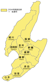
Sawata, Niigata
Sawata (佐和田町, Sawata-machi) was a town located in Sado Island, Niigata Prefecture, Japan.[1]
Sawata 佐和田町 | |
|---|---|
Former municipality | |
 Flag  Emblem | |
| Country | Japan |
| Region | Hokuriku |
| Prefecture | Niigata Prefecture |
| District | Sado District |
| Merged | March 1, 2004 (now part of Sado) |
| Area | |
| • Total | 47.7 km2 (18.4 sq mi) |
| Population (2004) | |
| • Total | 9,909 |
| Time zone | UTC+9 (JST) |

10 subdivisions (former municipalities) in the Sado City. Sawata is located on the west of the island.
On March 1, 2004, Sawata and the other 9 municipalities in the island were merged to create the city of Sado. Since then, Sawata has been one of the 10 subdivisions of Sado City.
Transportation
Bus
- Niigata Kotsu Sado
- Sawata Bus Station
Highway
gollark: It is a regex in a Markdown parser.
gollark: ```^(?:(\*(?=[`\]!"#$%&'()+\-./:;<=>?@\[^_{|}~]))|\*)(?![\*\s])((?:(?:(?!\[.*?\]|`.*?`|<.*?>)(?:[^\*]|[\\s]\*)|\[.*?\]|`.*?`|<.*?>)|(?:(?:(?!\[.*?\]|`.*?`|<.*?>)(?:[^\*]|[\\s]\*)|\[.*?\]|`.*?`|<.*?>)*?(?<!\)\*){2})*?)(?:(?<![`\s\]!"#$%&'()+\-./:;<=>?@\[^_{|}~])\*(?!\*)|(?<=[`\]!"#$%&'()+\-./:;<=>?@\[^_{|}~])\*(?!\*)(?:(?=[`\s\]!"#$%&'()+\-./:;<=>?@\[^_{|}~]|$)))|^_([^\s_])_(?!_)|^_([^\s_<][\s\S]*?[^\s_])_(?!_|[^\s,!"#$%&'()+\-./:;<=>?@\[^_{|}~])|^_([^\s_<][\s\S]*?[^\s])_(?!_|[^\s,!"#$%&'()+\-./:;<=>?@\[^_{|}~])```
gollark: Bees?
gollark: Alignment?
gollark: The proposal should declare what each operation should do on integers.
See also
References
- "佐和田町" (PDF). Niigata Prefectural Government (in Japanese). Archived from the original (PDF) on 5 April 2004.
This article is issued from Wikipedia. The text is licensed under Creative Commons - Attribution - Sharealike. Additional terms may apply for the media files.