Saraswati River (Bengal)
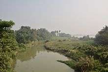
Saraswati River (Bengali: সরস্বতী নদী Shôrôshôti Nôdi) refers to a river, that was a distributary of the Bhagirathi and is now no more there but was active till around the 16th century AD.[1] The course and condition of the Saraswati has played an important role in the development and decline of river port towns in Bengal. Initially, the major port town was Tamralipta, after the decline of which Saptagram rose and declined, and finally Kolkata came up.

Earlier course
At Tribeni near Bandel in Hooghly District in the Indian state of West Bengal the Bhagirathi branched off into three streams. The Saraswati flowed south-west beyond Saptagram, the Jamuna (this is distinct from the river of same name in northern India and several streams of the same name in eastern Bengal) flowed south-east, past the northern boundary of present-day town of Kalyani and the Bhagirathi proper flowing through the present Hooghly channel to Kolkata and then through Adi Ganga, past Kalighat, to the sea. It is believed that the Saraswati flowed into an estuary near present-day Tamluk and received the waters of not only the Rupnarayan and Damodar but several other smaller streams. Some time after the 8th century AD, Tamralipta lost its importance primarily on account of silting up of the mouth of Saraswati and the consequent shifting of its course.[1]
It is believed that the Saraswati had an independent course to the sea.

Change in course
In the 16th century, the main waters of the Bhagirathi, which earlier used to flow through the Saraswati, started flowing through the Hooghly channel. In the course of time, the upper Saraswati dried up, but the Bhagirathi or Hooghly has abandoned the old Adi Ganga channel and flows through the lower course of the Saraswati below Sankrail.[1][4]
History
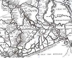
There is a clear indication of the river in Van den Brouck’s map of 1660. A hundred and fifty years prior to Van den Brouck’s map, the Bengali poet Bipradas Pipilai gave an account of the river and the surrounding area in his Manasamangal. As the merchant ship of the trader Chand Sadagar proceeded to the sea, he passed through Triveni and Saptagram and the tri junction of the Ganges, Saraswati and Yamuna.[5] He wrote:
- Gongo ar Soroshati, Jomuna bishal oti [6]
- (The Ganges and Saraswati, the Jamuna so large)
References
- Majumdar, Dr. R.C., History of Ancient Bengal, First published 1971, Reprint 2005, pp. 2-3, Tulshi Prakashani, Kolkata, ISBN 81-89118-01-3.
- Ray, Aniruddha (2012). "Satgaon". In Islam, Sirajul; Jamal, Ahmed A. (eds.). Banglapedia: National Encyclopedia of Bangladesh (Second ed.). Asiatic Society of Bangladesh.
- Roy, Niharranjan, Bangalir Itihas, Adi Parba, (in Bengali), first published 1972, reprint 2005, p. 126, Dey’s Publishing, 13 Bankim Chatterjee Street, Kolkata, ISBN 81-7079-270-3
- Ghosh, S.(2011), ‘Protecting Natural Resources: Course of a River Movement’, Community Development Journal, Vol. 46 (4),pp. 542-557. DOI: 10.1093/cdj/bsq007
- Roy, Niharranjan, p. 75
- Patree, Purnendu, Purano Kolkatar Kathachitra, (in Bengali), p.69, Dey’s Publishing, Kolkata, ISBN 81-7079-751-9