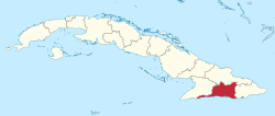
Santiago de Cuba Province
Santiago de Cuba Province is the second most populated province in the island of Cuba. The largest city Santiago de Cuba is the main administrative center. Other large cities include Palma Soriano, Contramaestre, San Luis and Songo-la Maya.
Santiago de Cuba Province | |
|---|---|
 Flag  Coat of arms | |
 | |
| Coordinates: 20°12′N 75°55′W | |
| Country | Cuba |
| Capital | Santiago de Cuba |
| Area | |
| • Total | 6,234.16 km2 (2,407.02 sq mi) |
| Population (2010-12-31)[1] | |
| • Total | 1,047,015 |
| • Density | 170/km2 (430/sq mi) |
| Time zone | UTC-5 (EST) |
| Area code(s) | +53-226 |
History
Santiago de Cuba province has been the site of many battles, both during the war for independence and the 1959 Cuban Revolution, where much of the guerrilla fighting took place in the mountainous province.
Prior to 1976, Cuba was divided into six historical provinces. One of these was Oriente province, which was, prior to 1905, known as Santiago de Cuba province. The present day province comprises the south-central region of Oriente.
Economy
The province is rich in material resources such as iron and nickel. The economy, however, relies mostly on agriculture, with large plantations growing bananas, cacao, and coffee dotting the landscape. Industry is growing around the capital, as is tourism. The natural environment of the province attracts tourists from elsewhere in Cuba and from overseas.
Municipalities
| Municipality | Population (2004) | Area (km²) | Location | Remarks |
|---|---|---|---|---|
| Contramaestre | 105,493 | 610.3 | 20.30000°N 76.25056°W | |
| Guamá | 35,516 | 965 | 19.97611°N 76.40972°W | Chivirico |
| Mella | 33,667 | 335.2 | 20.36944°N 75.91083°W | |
| Palma Soriano | 124,585 | 845.8 | 20.21417°N 75.99167°W | |
| San Luis | 88,496 | 765 | 20.18806°N 75.84861°W | |
| Santiago de Cuba | 472,255 | 1,023.8 | 20.04028°N 75.81472°W | Provincial capital |
| Segundo Frente | 40,885 | 540 | 20.41194°N 75.52861°W | Mayarí Arriba |
| Songo-La Maya | 100,287 | 721 | 20.17333°N 75.64611°W | La Maya |
| Tercer Frente | 30,457 | 364 | 20.17194°N 76.32722°W | Cruce de los Baños |
Demographics
In 2004, the province of Santiago De Cuba had a population of 1,043,202.[2] With a total area of 6,156.44 km2 (2,377.01 sq mi),[4] the province had a population density of 169.4/km2 (439/sq mi).
International relations
See also
- Oriente Province
- Roman Catholic Diocese of Cubao
- Father José Conrado
References
- "Lugar que ocupa el territorio según la superficie y la población" (PDF). Una MIRADA a Cuba (in Spanish). Oficina Nacional de Estadísticas. Cuba. 2010.
- Atenas.cu (2004). "2004 Population trends, by Province and Municipality" (in Spanish). Archived from the original on 2007-09-27. Retrieved 2007-10-06.
- Statoids (July 2003). "Municipios of Cuba". Retrieved 2007-10-06.
- Government of Cuba (2002). "Population by Province" (in Spanish). Retrieved 2007-10-05.
- Vacca, Maria Luisa. "Comune di Napoli -Gemellaggi" [Naples - Twin Towns]. Comune di Napoli (in Italian). Archived from the original on 2013-07-22. Retrieved 2013-08-08.
External links
| Wikimedia Commons has media related to Santiago de Cuba Province. |