Sainte-Geneviève-des-Bois, Loiret
Sainte-Geneviève-des-Bois is a commune in the Loiret department in north-central France.
Sainte-Geneviève-des-Bois | |
|---|---|
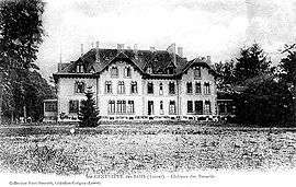
 Château des Bézards | |
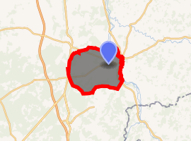
Location of Sainte-Geneviève-des-Bois 
| |
 Sainte-Geneviève-des-Bois  Sainte-Geneviève-des-Bois | |
| Coordinates: 47°49′01″N 2°49′01″E | |
| Country | France |
| Region | Centre-Val de Loire |
| Department | Loiret |
| Arrondissement | Montargis |
| Canton | Lorris |
| Intercommunality | Canaux et Forêts en Gâtinais |
| Government | |
| • Mayor (2001–2008) | André Jean |
| Area 1 | 40.74 km2 (15.73 sq mi) |
| Population (2017-01-01)[1] | 1,083 |
| • Density | 27/km2 (69/sq mi) |
| Time zone | UTC+01:00 (CET) |
| • Summer (DST) | UTC+02:00 (CEST) |
| INSEE/Postal code | 45278 /45230 |
| 1 French Land Register data, which excludes lakes, ponds, glaciers > 1 km2 (0.386 sq mi or 247 acres) and river estuaries. | |
Geography
The villages lies in the middle of the commune, on the right bank of the Talot, which forms part of the commune's northern border, then flows into the Loing, which forms the commune's eastern border.
_-_00.jpg)
The church.
gollark: Well, you basically use the live USB, configure your partitions, install the base system packages, chroot into the new system, configure things, install a bootloader, reboot, then install/configure a desktop environment and whatnot.
gollark: Just get a 1km Ethernet cable.
gollark: Do you *need* wireless connectivity, really?
gollark: Great, you should be fine.
gollark: Also, Arch has really good docuentation.
See also
References
- "Populations légales 2017". INSEE. Retrieved 6 January 2020.
| Wikimedia Commons has media related to Sainte-Geneviève-des-Bois, Loiret. |
This article is issued from Wikipedia. The text is licensed under Creative Commons - Attribution - Sharealike. Additional terms may apply for the media files.