Saint Marys Parish, New Brunswick
Saint Marys is a civil parish[lower-alpha 1] in York County, New Brunswick, Canada.[2]
Saint Marys Saint Mary's, St, Mary's, St. Marys | |
|---|---|
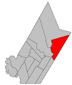 Location within York County, New Brunswick. | |
| Coordinates: 46.205°N 66.505°W | |
| Country | |
| Province | |
| County | York |
| Established | 1786 |
| Area | |
| • Land | 752.68 km2 (290.61 sq mi) |
| Population (2016)[1] | |
| • Total | 4,837 |
| • Density | 6.4/km2 (17/sq mi) |
| • Change 2011-2016 | |
| • Dwellings | 1,944 |
| Time zone | UTC-4 (AST) |
| • Summer (DST) | UTC-3 (ADT) |
For governance purposes it is divided between the city of Fredericton[3] and the local service district of the parish of Saint Marys,[4] which further includes the special service areas of Evergreen Park and Pepper Creek.
Delineation
Saint Marys Parish is defined in the Territorial Division Act[2] as being bounded:
- South by the City of Fredericton as now bounded;[lower-alpha 2] west by Stanley Parish and a line to commence at the most western angle of lot numbered thirty-one, letter D, in the Maryland Loyalists’ grant; thence northeasterly along the upper line of said lot to the rear thereof; thence north forty-five degrees west to the east line of lot numbered one, granted to D. Sawyer; thence north to Stanley Parish; north by Stanley Parish, and southeast by the County line.
Communities
Parish population total does not include incorporated municipalities (in bold):
|
|
|
Demographics
Population
|
LanguageMother tongue (2016)[1]
|
gollark: Already done that.
gollark: No. I dislike it.
gollark: It is not.
gollark: Okay, listening.
gollark: I would ask for krist, but it's centralized and the server went down due to backup issues.
See also
Notes
- Civil parishes served a variety of government functions until 1966, when the new Municipalities Act stripped them of their responsibilities; they continue to provide convenient boundaries for government uses, especially electoral districts and local service districts. Statistics Canada uses civil parishes as census subdivisions for all parts of the province that are not within municipalities and similar entities.
- The wording is a carryover from when the Act was originally written; the boundaries of Fredericton now take in part of the parish.
References
- "Census Profile, 2016 Census: Saint Marys, Parish [Census subdivision], New Brunswick". Statistics Canada. Retrieved October 8, 2019.
- "Chapter T-3 Territorial Division Act". Government of New Brunswick. Retrieved 25 July 2020.
- "New Brunswick Regulation 85-6 under the Municipalities Act (O.C. 85-45)". Government of New Brunswick. Retrieved 25 July 2020.
- "New Brunswick Regulation 84-168 under the Municipalities Act (O.C. 84-582)". Government of New Brunswick. Retrieved 25 July 2020.
- Statistics Canada: 1996, 2001, 2006 census
- 2006 Statistics Canada Community Profile: Saint Marys Parish, New Brunswick
- 2011 Statistics Canada Census Profile: Saint Marys Parish, New Brunswick
Places adjacent to Saint Marys Parish, New Brunswick | |
|---|---|
| Subdivisions |
|
|---|---|
| Cities | |
| Counties | |
| |
This article is issued from Wikipedia. The text is licensed under Creative Commons - Attribution - Sharealike. Additional terms may apply for the media files.