Douglas Parish, New Brunswick
Douglas is a civil parish[lower-alpha 1] in York County, New Brunswick, Canada.[2]
Douglas | |
|---|---|
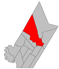 Location within York County, New Brunswick. | |
| Coordinates: 45.98°N 66.7325°W | |
| Country | |
| Province | |
| County | York |
| Established | 1824 |
| Area | |
| • Land | 1,446.95 km2 (558.67 sq mi) |
| Population (2016)[1] | |
| • Total | 6,154 |
| • Density | 4.3/km2 (11/sq mi) |
| • Change 2011-2016 | |
| • Dwellings | 2,546 |
| Time zone | UTC-4 (AST) |
| • Summer (DST) | UTC-3 (ADT) |
For governance purposes it is divided between the city of Frederictonand the local service districts of Estey's Bridge and the parish of Douglas,[3] which further includes the special service areas of Carlisle Road and Lower Douglas.
History
Douglas Parish was established in (before 1813) as part of York County. It is not known for whom the Parish was named.
Delineation
Douglas Parish is defined in the Territorial Division Act[2] as being bounded:
- South and southeast by the Saint John River and the City of Fredericton; west by a line commencing at the mouth of the Keswick River; thence following the various courses of the said Keswick River up to the mouth of the Howard Brook; thence by the magnet of the year one thousand eight hundred and sixty-nine north forty degrees west till it strikes the County line; northwest by the County line, and east by Stanley and Saint Marys Parishes, including Upper Shores, Lower Shores, Mitchells, Merrithews[lower-alpha 2] and Keswick Islands, and the north range of lots, comprising lots number one to number nine, inclusive, and number thirty-seven to number seventy-one, inclusive, on Sugar Island.
Communities
Parish population total does not include incorporated municipalities (in bold):
|
|
|
Demographics
Population
|
LanguageMother tongue (2016)[1]
|
gollark: (then, not than)
gollark: It would probably be best to make a government which is actually competent, *somehow*, then have it do more things.
gollark: Look at the whole mess with COVID-19 testing in the US.
gollark: Because often the government is *awful* at its job.
gollark: The whole insurance thing just creates a bunch of indirection, so people can just set the prices stupidly high and insurance just pays it.
See also
Notes
- Civil parishes served a variety of government functions until 1966, when the new Municipalities Act stripped them of their responsibilities; they continue to provide convenient boundaries for government uses, especially electoral districts and local service districts. Statistics Canada uses civil parishes as census subdivisions for all parts of the province that are not within municipalities and similar entities.
- Officially a former name for Lower Shores Island, this may actually refer to one of the small islands between Lower Shores and Upper Shores Islands.
References
- "Census Profile, 2016 Census Douglas, Parish [Census subdivision], New Brunswick". Statistics Canada. Retrieved October 8, 2019.
- "Chapter T-3 Territorial Division Act". Government of New Brunswick. Retrieved 25 July 2020.
- "New Brunswick Regulation 84-168 under the Municipalities Act (O.C. 84-582)". Government of New Brunswick. Retrieved 25 July 2020.
- Statistics Canada: 1996, 2001, 2006 census
- 2006 Statistics Canada Community Profile: Douglas Parish, New Brunswick
- 2011 Statistics Canada Census Profile: Douglas Parish, New Brunswick
External links
Places adjacent to Douglas Parish, New Brunswick | |
|---|---|
| Subdivisions |
|
|---|---|
| Cities | |
| Counties | |
| |
This article is issued from Wikipedia. The text is licensed under Creative Commons - Attribution - Sharealike. Additional terms may apply for the media files.