Saint-Vérand, Rhône
Saint-Vérand is a commune in the Rhône department in eastern France.
Saint-Vérand | |
|---|---|
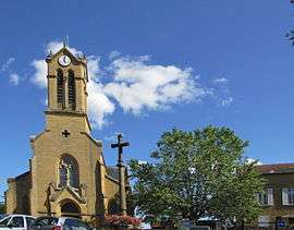
 The church in Saint-Vérand | |
.svg.png) Coat of arms | |
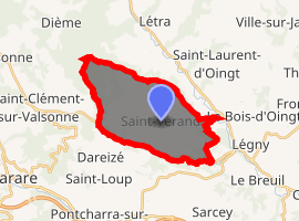
Location of Saint-Vérand 
| |
 Saint-Vérand  Saint-Vérand | |
| Coordinates: 45°55′11″N 4°31′41″E | |
| Country | France |
| Region | Auvergne-Rhône-Alpes |
| Department | Rhône |
| Arrondissement | Villefranche-sur-Saône |
| Canton | Le Bois-d'Oingt |
| Government | |
| • Mayor (2008–2014) | Gérard Chardon |
| Area 1 | 17.58 km2 (6.79 sq mi) |
| Population (2017-01-01)[1] | 1,192 |
| • Density | 68/km2 (180/sq mi) |
| Time zone | UTC+01:00 (CET) |
| • Summer (DST) | UTC+02:00 (CEST) |
| INSEE/Postal code | 69239 /69620 |
| Elevation | 258–686 m (846–2,251 ft) (avg. 385 m or 1,263 ft) |
| 1 French Land Register data, which excludes lakes, ponds, glaciers > 1 km2 (0.386 sq mi or 247 acres) and river estuaries. | |
Population and housing of Saint-Vérand
The population of Saint-Vérand was 993 in 1999, 1082 in 2006, and 1090 in 2007. The population density of Saint-Vérand is 62.00 inhabitants per km². The number of housing of Saint-Vérand was 533 in 2007. These homes of Saint-Vérand consist of 432 main residences, 68 second or occasional homes and 33 vacant homes.
gollark: That is not how discrimination works.
gollark: ubq323 is wrong in all cases.
gollark: ubq323 is several bees.
gollark: No.
gollark: It's not JUST programming.
See also
References
- "Populations légales 2017". INSEE. Retrieved 6 January 2020.
This article is issued from Wikipedia. The text is licensed under Creative Commons - Attribution - Sharealike. Additional terms may apply for the media files.