Saint-Bonnet-des-Bruyères
Saint-Bonnet-des-Bruyères is a commune in the Rhône department in eastern France.
Saint-Bonnet-des-Bruyères | |
|---|---|
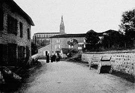 Saint-Bonnet-des-Bruyères, in the early 20th century | |
Location of Saint-Bonnet-des-Bruyères 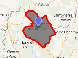
| |
 Saint-Bonnet-des-Bruyères  Saint-Bonnet-des-Bruyères | |
| Coordinates: 46°16′15″N 4°28′12″E | |
| Country | France |
| Region | Auvergne-Rhône-Alpes |
| Department | Rhône |
| Arrondissement | Villefranche-sur-Saône |
| Canton | Thizy-les-Bourgs |
| Intercommunality | Saône-Beaujolais |
| Government | |
| • Mayor (2014–2020) | Martine Cartillier |
| Area 1 | 21.20 km2 (8.19 sq mi) |
| Population (2017-01-01)[1] | 356 |
| • Density | 17/km2 (43/sq mi) |
| Time zone | UTC+01:00 (CET) |
| • Summer (DST) | UTC+02:00 (CEST) |
| INSEE/Postal code | 69182 /69790 |
| Elevation | 413–801 m (1,355–2,628 ft) |
| 1 French Land Register data, which excludes lakes, ponds, glaciers > 1 km2 (0.386 sq mi or 247 acres) and river estuaries. | |
Geography
The river Grosne has its source in the commune.
gollark: I think he's in Australia or something. They might have stricter laws, like the UK, about guns and such.
gollark: Also, the borders and anything near them (!!!) are apparently exempt from constitutional protections against excessive search?
gollark: I mean, mostly. There's the no-fly list, so not *entirely*.
gollark: Bye then, enjoy your whatever.
gollark: It seems to *mostly* be the US.
See also
References
- "Populations légales 2017". INSEE. Retrieved 6 January 2020.
| Wikimedia Commons has media related to Saint-Bonnet-des-Bruyères. |
| Authority control |
|
|---|
This article is issued from Wikipedia. The text is licensed under Creative Commons - Attribution - Sharealike. Additional terms may apply for the media files.